Geolocate

Bella Vista topographic map

Interactive map

Click on the map to display elevation.

About this map

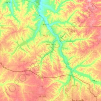
Name: Bella Vista topographic map, elevation, terrain.

Location: Bella Vista, Benton County, Arkansas, 72715, United States (36.41540 -94.37568 36.49960 -94.16197)

Average elevation: 372 m

Minimum elevation: 283 m

Maximum elevation: 447 m

The city of Bella Vista is located on the Springfield Plateau of the Ozark Mountains. Oak/hickory forests, along with valleys, creeks, and steep rises, characterize the city's topography. Bella Vista is located north of Bentonville and Rogers within the Northwest Arkansas region. The city has been experiencing a population and building boom in recent years, as indicated by a 60% growth in population between the 2000 and 2010 censuses.

Wikipedia (CC-BY-SA 3.0)

Other topographic maps

Click on a map to view its topography, its elevation and its terrain.

Rogers

United States > Arkansas > Benton County

Rogers, Benton County, Arkansas, United States

Average elevation: 393 m

Bentonville

United States > Arkansas > Benton County

Bentonville, Benton County, Arkansas, United States

Average elevation: 387 m

Beaver Lake

United States > Arkansas > Benton County > Goshen

Beaver Lake, Goshen, Benton County, Arkansas, 72757, United States

Average elevation: 394 m

Lost Bridge Village

United States > Arkansas > Benton County

Lost Bridge Village, Benton County, Arkansas, United States

Average elevation: 377 m

Maysville

United States > Arkansas > Benton County

Maysville, Benton County, Arkansas, 72747, United States

Average elevation: 323 m

Decatur

United States > Arkansas > Benton County

Decatur, Benton County, Arkansas, 72722, United States

Average elevation: 379 m

Gateway

United States > Arkansas > Benton County

Gateway, Benton County, Arkansas, 72733, United States

Average elevation: 467 m

Little Flock

United States > Arkansas > Benton County

Little Flock, Benton County, Arkansas, United States

Average elevation: 388 m

Springtown

United States > Arkansas > Benton County

Springtown, Benton County, Arkansas, 72734, United States

Average elevation: 388 m

Siloam Springs

United States > Arkansas > Benton County

Siloam Springs, Benton County, Arkansas, 72761, United States

Average elevation: 339 m

Hiwasse

United States > Arkansas > Benton County > Gravette

Hiwasse, Gravette, Benton County, Arkansas, 72739, United States

Average elevation: 394 m

Benton Country Fair Grounds

United States > Arkansas > Benton County > Bentonville

Benton Country Fair Grounds, Bentonville, Benton County, Arkansas, United States

Average elevation: 384 m

Lake Avalon

United States > Arkansas > Benton County > Bella Vista

Lake Avalon, Bella Vista, Benton County, Arkansas, 72715, United States

Average elevation: 353 m

Rago

United States > Arkansas > Benton County > Bella Vista

Rago, Bella Vista, Benton County, Arkansas, 72715, United States

Average elevation: 378 m

Loch Lomond

United States > Arkansas > Benton County > Bella Vista

Loch Lomond, Bella Vista, Benton County, Arkansas, 72715, United States

Average elevation: 360 m

Dug Hill

United States > Arkansas > Benton County > Bella Vista

Dug Hill, Bella Vista, Benton County, Arkansas, 72715, United States

Average elevation: 344 m

Centerton

United States > Arkansas > Benton County

Centerton, Benton County, Arkansas, 72719, United States

Average elevation: 393 m

Pedro

United States > Arkansas > Benton County

Pedro, Benton County, Arkansas, United States

Average elevation: 334 m

Lake Windsor

United States > Arkansas > Benton County > Bella Vista

Lake Windsor, Bella Vista, Benton County, Arkansas, 72715, United States

Average elevation: 352 m

Silent Grove

United States > Arkansas > Benton County > Springdale

Silent Grove, Springdale, Benton County, Arkansas, 72762, United States

Average elevation: 394 m

Cave Springs

United States > Arkansas > Benton County

Cave Springs, Benton County, Arkansas, 72718, United States

Average elevation: 375 m

Gravette

United States > Arkansas > Benton County

Gravette, Benton County, Arkansas, United States

Average elevation: 356 m

Siloam Springs Lake

United States > Arkansas > Benton County > Siloam Springs

Siloam Springs Lake, Siloam Springs, Benton County, Arkansas, United States

Average elevation: 341 m

Healing Springs

United States > Arkansas > Benton County

Healing Springs, Benton County, Arkansas, United States

Average elevation: 365 m

Garfield

United States > Arkansas > Benton County

Garfield, Benton County, Arkansas, 72732, United States

Average elevation: 453 m

Oak Grove

United States > Arkansas > Benton County > Oak Grove

Oak Grove, Benton County, Arkansas, 72757, United States

Average elevation: 362 m

Lake Springdale

United States > Arkansas > Benton County > Springdale

Lake Springdale, Springdale, Benton County, Arkansas, United States

Average elevation: 392 m

Lowell

United States > Arkansas > Benton County

Lowell, Benton County, Arkansas, United States

Average elevation: 404 m

Sulphur Springs

United States > Arkansas > Benton County

Sulphur Springs, Benton County, Arkansas, United States

Average elevation: 308 m

Gentry

United States > Arkansas > Benton County

Gentry, Benton County, Arkansas, 72734, United States

Average elevation: 371 m

Bella Vista

United States > Arkansas > Benton County > Bella Vista > Bella Vista

Bella Vista, Benton County, Arkansas, 72715, United States

Average elevation: 359 m

Garfield

United States > Arkansas > Benton County > Garfield

Garfield, Benton County, Arkansas, 72732, United States

Average elevation: 453 m

Pea Ridge

United States > Arkansas > Benton County

Pea Ridge, Benton County, Arkansas, 72751, United States

Average elevation: 393 m