
Keçiören topographic map
Interactive map
Click on the map to display elevation.
About this map
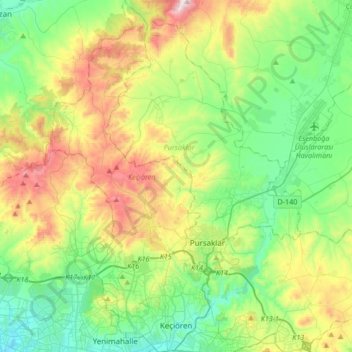
Name: Keçiören topographic map, elevation, terrain.
Location: Keçiören, Ankara, Central Anatolia Region, Turkey (39.95796 32.74117 40.21530 32.90115)
Average elevation: 1,074 m
Minimum elevation: 816 m
Maximum elevation: 1,626 m
Keçiören is a metropolitan district of Ankara Province in the Central Anatolia region of Turkey, a crowded district in the northern part of the city of Ankara. According to 2010 census, population of the district center is 817,262 The district covers an area of 190 km2 (73 sq mi), and the average elevation is 850 m (2,789 ft). The Çubuk River runs through the middle of the district.
Other topographic maps
Click on a map to view its topography, its elevation and its terrain.
Kalaba Mahallesi
Kalaba Mahallesi, Keçiören, Ankara, Central Anatolia Region, Turkey
Average elevation: 894 m
Ufuktepe Mahallesi
Ufuktepe Mahallesi, Keçiören, Ankara, Central Anatolia Region, Turkey
Average elevation: 1,053 m
İncirli Mahallesi
İncirli Mahallesi, Keçiören, Ankara, Central Anatolia Region, Turkey
Average elevation: 955 m
Karakaya Mahallesi
Karakaya Mahallesi, Keçiören, Ankara, Central Anatolia Region, 06291, Turkey
Average elevation: 1,163 m
Şefkat Mahallesi
Şefkat Mahallesi, Keçiören, Ankara, Central Anatolia Region, Turkey
Average elevation: 900 m
Yeşiltepe Mahallesi
Yeşiltepe Mahallesi, Keçiören, Ankara, Central Anatolia Region, Turkey
Average elevation: 943 m