
Bayraklı topographic map
Interactive map
Click on the map to display elevation.
About this map
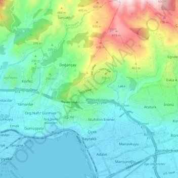
Name: Bayraklı topographic map, elevation, terrain.
Location: Bayraklı, Izmir, Aegean Region, Turkey (38.44708 27.11156 38.52640 27.20338)
Average elevation: 224 m
Minimum elevation: -2 m
Maximum elevation: 932 m
Other topographic maps
Click on a map to view its topography, its elevation and its terrain.
Gümüşpala Mahallesi
Gümüşpala Mahallesi, Bayraklı, Izmir, Aegean Region, Turkey
Average elevation: 35 m
Doğançay Mahallesi
Doğançay Mahallesi, Bayraklı, Izmir, Aegean Region, 35510, Turkey
Average elevation: 321 m