
Monein topographic map
Interactive map
Click on the map to display elevation.
About this map
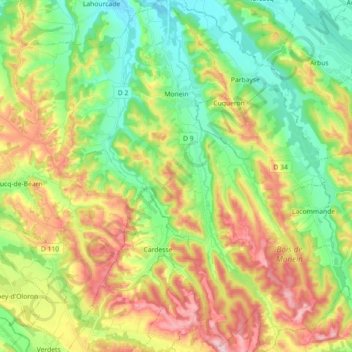
Name: Monein topographic map, elevation, terrain.
Average elevation: 212 m
Minimum elevation: 111 m
Maximum elevation: 365 m
Other topographic maps
Click on a map to view its topography, its elevation and its terrain.
Sumberraute
France > Nouvelle-Aquitaine > Pyrénées-Atlantiques
Sumberraute, Bayonne, Pyrénées-Atlantiques, Nouvelle-Aquitaine, Metropolitan France, France
Average elevation: 88 m