Geolocate

La Orotava topographic map

Interactive map

Click on the map to display elevation.

La Orotava

The town La Orotava, which is the administrative centre of the municipality and also its largest settlement, is situated near the north coast, at about 400 m elevation in the Orotava Valley. It is 4 km southeast of Puerto de la Cruz and 28 km southwest of the island's capital, Santa Cruz de Tenerife. The TF-5 motorway passes through the north of the municipality.

Wikipedia (CC-BY-SA 3.0)

About this map

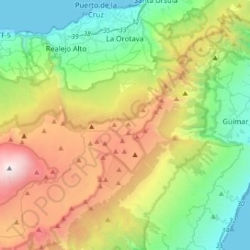
Name: La Orotava topographic map, elevation, terrain.

Location: La Orotava, Santa Cruz de Tenerife, Canary Islands, Spain (28.19873 -16.68387 28.42427 -16.46357)

Average elevation: 1,257 m

Minimum elevation: 0 m

Maximum elevation: 3,685 m

Other topographic maps

Click on a map to view its topography, its elevation and its terrain.

Bricia

Spain > Castile and León > Alfoz de Bricia

Average elevation: 979 m

As Vendas da Barreira

Spain > Galicia > Verín > Riós

Average elevation: 802 m

Bellfort

Spain > Catalonia > Noguera > la Baronia de Rialb

Average elevation: 580 m

Son Blanc

Spain > Balearic Islands > Menorca > Ciutadella > sa Caleta

Average elevation: 11 m

Santinos

Spain > Castile and León > Tudela de Duero

Average elevation: 707 m

Es Corrals

Spain > Balearic Islands

Average elevation: 8 m

Pozacas

Spain > Asturias > Grandas de Salime > Silvañá

Average elevation: 758 m

Navatejera

Spain > Castile and León > Villaquilambre

Average elevation: 868 m

Troncéu

Spain > Asturias > Cudillero

Average elevation: 190 m

Presa de Almendra

Spain > Castile and León > Almendra

Average elevation: 699 m

El Coto

Spain > Castile and León > Cuadros

Average elevation: 917 m

Menorca

Spain > Balearic Islands > Es Migjorn Gran

Average elevation: 9 m

San Juan

Spain > Valencian Community > Villena > La Puentecilla

Average elevation: 495 m

San Juan

Spain > Valencian Community > Villena > La Puentecilla

Average elevation: 495 m

El Abiar

Spain > Andalusia > Los Vélez > Vélez-Blanco

Average elevation: 994 m

O Picón

Spain > Galicia > Ortegal > Ortigueira

Average elevation: 36 m

Alhambra

Spain > Andalusia > Partido Judicial de Granada > Granada

During the reign of the Nasrid Dynasty, the Alhambra was transformed into a palatine city, complete with an irrigation system composed of aqueducts and water channels that provided water for the complex and for other nearby countryside palaces such as the Generalife. Previously, the old fortresses on the hill…

Average elevation: 759 m

Rícmar

Spain > Andalusia > Costa del Sol Occidental > Marbella

Average elevation: 35 m

O Porto de Santa Cruz

Spain > Galicia > A Coruña

Average elevation: 40 m

La Presidenta

Spain > Catalonia > Baix Llobregat > Collbató

Average elevation: 753 m

Campillo del Moro

Spain > Andalusia

Average elevation: 140 m

Bel-Air

Spain > Andalusia > Costa del Sol Occidental > Estepona

Average elevation: 35 m

Baua

Spain > Asturias > Ribeseya

Average elevation: 322 m

La Maliciosa

Spain > Community of Madrid > Navacerrada

La Maliciosa is one of the most important and highest mountains of the Sierra de Guadarrama, a mountainous formation belonging to the Sistema Central. It has an altitude of 2227m above sea level and is located in the northwest of the Community of Madrid, in Spain, rising between La Pedriza, which lies to the…

Average elevation: 1,856 m

Rubalcaba

Spain > Cantabria > Liérganes

Average elevation: 287 m

La Restinga

Spain > El Pinar de El Hierro

Average elevation: 50 m

Churra

Spain > Region of Murcia > Alto Guadalentín > Lorca

Average elevation: 332 m

Costa Brava

Spain

Average elevation: 247 m

Cala Vedella

Spain > Balearic Islands > Ibiza

Average elevation: 62 m

Manacor

Spain > Balearic Islands > Llevant

Average elevation: 100 m

Los Yesos

Spain > Andalusia > Tabernas

Average elevation: 532 m

Lois

Spain > Castile and León > Crémenes

Average elevation: 1,466 m

Cabanes de la Serra

Spain > Catalonia > Ripollès > Setcases

Average elevation: 1,661 m

La Ral

Spain > Aragon > Campo de Belchite > Azuara

Average elevation: 674 m

Monticelo

Spain > Asturias > Vegadeo

Average elevation: 532 m

Mirasol

Spain > Aragon > Valdejalón > Calatorao

Average elevation: 409 m

El Mesegar

Spain > Castile and León > Olmedo

Average elevation: 740 m

Montijos

Spain > La Orotava

Average elevation: 499 m

Montecelo

Spain > Galicia > O Morrazo > Marín

Average elevation: 48 m

Puigmal

Spain > Catalonia > Ripollès > Queralbs

Average elevation: 2,572 m

Cuatro Caminos

Spain > Cantabria > Santander

Average elevation: 20 m

La Pallara

Spain > Castile-La Mancha > El Bonillo

Average elevation: 1,012 m

Tamia

Spain > Teguise

Average elevation: 311 m

Castilla

Spain > Castile-La Mancha > Campo de Criptana

Average elevation: 643 m

Garabandal

Spain > Cantabria > Rionansa

Average elevation: 611 m

Henares

Spain > Region of Murcia > Alto Guadalentín > Lorca

Average elevation: 777 m

Columba

Spain > Extremadura > Perales del Puerto

Average elevation: 407 m

San Antolín de Ibias

Spain > Asturias > Ibias

Average elevation: 550 m

Martín Sanz

Spain > Castile-La Mancha > El Bonillo

Average elevation: 1,008 m

Sa Figuera

Spain > Balearic Islands > Pla de Mallorca > Montuïri

Average elevation: 159 m

Baranda

Spain > Cantabria > Escalante

Average elevation: 54 m

Los Molinas

Spain > Andalusia > Valle del Almanzora > Albox

Average elevation: 855 m

Quarts

Spain > Catalonia > Segrià > Corbins

Average elevation: 183 m

Artola

Spain > Andalusia > Costa del Sol Occidental > Marbella

Average elevation: 55 m

Taco

Spain > San Cristóbal de La Laguna

Average elevation: 298 m

Los Cristianos

Spain

Average elevation: 85 m

la Marina

Spain > Valencian Community > Elx / Elche

Average elevation: 22 m

Granda de Riba

Spain > Asturias > Gijón > Vega de Riba

Average elevation: 57 m

Cortina

Spain > Asturias > Oviedo

Average elevation: 309 m

Bances

Spain > Asturias > Pravia

Average elevation: 128 m

Peña Sobia

Spain > Asturias > Teverga

Average elevation: 898 m

Rozavales

Spain > Galicia > O Morrazo > Cangas

Average elevation: 77 m

Pico del Teide

Spain > La Orotava

Teide, or Mount Teide, (Spanish: El Teide, Pico del Teide, pronounced [ˈpiko ðel ˈtejðe], 'Peak of Teide') is a volcano on Tenerife in the Canary Islands, Spain. Its summit (at 3,715 m (12,188 ft)) is the highest point in Spain and the highest point above sea level in the islands of the Atlantic. If…

Average elevation: 3,200 m

Alhambra

Spain > Andalusia > Partido Judicial de Granada > Granada

During the reign of the Nasrid Dynasty, the Alhambra was transformed into a palatine city, complete with an irrigation system composed of aqueducts and water channels that provided water for the complex and for other nearby countryside palaces such as the Generalife. Previously, the old fortresses on the hill…

Average elevation: 759 m

Entrerríos

Spain > Andalusia > Costa del Sol Occidental

Average elevation: 121 m

Guadajira

Spain > Extremadura > Zafra - Río Bodión > Feria

Average elevation: 523 m

El Rocío

Spain > Andalusia > El Condado > Almonte

Average elevation: 9 m