
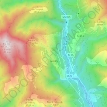
Bairols topographic map
Interactive map
Click on the map to display elevation.
About this map
Name: Bairols topographic map, elevation, terrain.
Average elevation: 867 m
Minimum elevation: 250 m
Maximum elevation: 1,788 m
Bairols is located at an altitude of 830 metres on a rocky ridge some 20 km north of Gilette and 5 km north of Villars-sur-Var. Access to the commune is by the M26 road from Tournefort in the south which passes through the south-eastern corner of the commune and connects with the tortuous M56 road which continues to the village. The commune is a rugged alpine commune.
Other topographic maps
Click on a map to view its topography, its elevation and its terrain.
Nice
France > Provence-Alpes-Côte d'Azur > Maritime Alps
Nice, Maritime Alps, Provence-Alpes-Côte d'Azur, Metropolitan France, France
Average elevation: 107 m