
Euboea topographic map
Interactive map
Click on the map to display elevation.
About this map
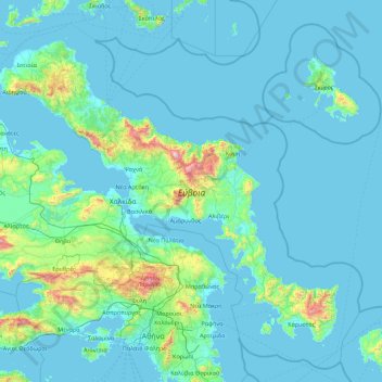
Name: Euboea topographic map, elevation, terrain.
Average elevation: 113 m
Minimum elevation: -1 m
Maximum elevation: 1,672 m
Other topographic maps
Click on a map to view its topography, its elevation and its terrain.
Mitikas
Greece > Thessaly - Central Greece
Mitikas, Skiathos Municipality, Regional Unit of Sporades, Region of Thessaly, Thessaly - Central Greece, 37002, Greece
Average elevation: 261 m
Pindus
Greece > Thessaly - Central Greece
Pindus, Δήμος Αργιθέας, Karditsa Regional Unit, Region of Thessaly, Thessaly - Central Greece, Greece
Average elevation: 1,510 m