
Toronto topographic map
Click on the map to display elevation.
Toronto
Despite its deep ravines, Toronto is not remarkably hilly, but its elevation does increase steadily away from the lake. Elevation differences range from 76.5 metres (251 ft) above sea level at the Lake Ontario shore to 209 m (686 ft) above sea level near the York University grounds in the city's north end at the intersection of Keele Street and Steeles Avenue. There are occasional hilly areas; in particular, midtown Toronto has several sharply sloping hills. Lake Ontario remains occasionally visible from the peaks of these ridges as far north as Eglinton Avenue, 7 to 8 kilometres (4.3 to 5.0 mi) inland.
About this map
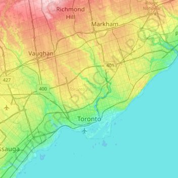
Name: Toronto topographic map, elevation, terrain.
Location: Toronto, Golden Horseshoe, Ontario, Canada (43.57961 -79.63928 43.85544 -79.11322)
Average elevation: 139 m
Minimum elevation: 70 m
Maximum elevation: 330 m
Other topographic maps
Click on a map to view its topography, its elevation and its terrain.
Toronto
Despite its deep ravines, Toronto is not remarkably hilly, but its elevation does increase steadily away from the lake. Elevation differences range from 76.5 metres (251 ft) above sea level at the Lake Ontario shore to 209 m (686 ft) ASL near the York University grounds in the city's north end at the…
Average elevation: 113 m
London
Canada > Ontario > London > London
London has a humid continental climate (Köppen Dfb), though due to its downwind location relative to Lake Huron and elevation changes across the city, it is virtually on the Dfa/Dfb (hot summer) boundary favouring the former climate zone to the southwest of the confluence of the South and North Thames Rivers,…
Average elevation: 268 m
Peterborough
Canada > Ontario > Peterborough
Peterborough's topography is largely defined by land formations created by the receding Wisconsian glaciers 10,000–15,000 years ago. The South End and Downtown portions of the City sit on what was the bottom of the glacial Lake Peterborough—part of a glacial spillway created when glacial meltwaters from…
Average elevation: 235 m
Port Loring
Canada > Ontario > Parry Sound District > Unorganized Centre Parry Sound
Average elevation: 227 m
Magnetawan River
Canada > Ontario > Parry Sound District > Unorganized Centre Parry Sound
Average elevation: 198 m
Manitouwabing Lake
Canada > Ontario > Parry Sound District > McKellar Township > McKellar
Average elevation: 249 m
Chesterville
Canada > Ontario > Stormont, Dundas and Glengarry Counties > North Dundas
Average elevation: 74 m
Ara Lake
Canada > Ontario > Thunder Bay District > Unorganized Thunder Bay District
Average elevation: 308 m
Guelph
This region of Ontario has cold winters and warm, humid summers, falling into the Köppen climate classification Dfb zone, with moderately high rainfall and snowfall. It is generally a couple of degrees cooler than lower elevation regions on the Great Lakes shorelines, especially so in winter, the exception…
Average elevation: 344 m
Burditt Lake
Canada > Ontario > Kenora District > Unorganized Kenora District
Average elevation: 367 m
Oxtongue Lake
Canada > Ontario > Haliburton County > Algonquin Highlands > Oxtongue Lake
Average elevation: 394 m
Queenston Heights Park
Canada > Ontario > Niagara Region > Niagara-on-the-Lake > Queenston
Average elevation: 139 m
Montreal River Harbour
Canada > Ontario > Algoma District > Unorganized North Algoma
Average elevation: 212 m
Whitefish Lake
Canada > Ontario > Thunder Bay District > Unorganized Thunder Bay District
Average elevation: 472 m
Lake Bernard
Canada > Ontario > Parry Sound District > Strong Township > Sundridge
Average elevation: 347 m
Madawaska River
Canada > Ontario > Renfrew County > Greater Madawaska > Calabogie
Average elevation: 160 m
Madawaska Highlands
Canada > Ontario > Nipissing District > South Algonquin Township
Average elevation: 442 m
Dollars Lake
Canada > Ontario > Parry Sound District > Unorganized Centre Parry Sound
Average elevation: 215 m
Collins
Canada > Ontario > Thunder Bay District > Unorganized Thunder Bay District
Average elevation: 386 m
Sioux Narrows
Canada > Ontario > Kenora District > Sioux Narrows-Nestor Falls Township
Average elevation: 329 m
Fort Irwin Conservation Area Trail Head
Canada > Ontario > Haliburton County > Dysart et al
Average elevation: 391 m
Lake Laurentian Conservation Area
Canada > Ontario > Sudbury District > Greater Sudbury > McFarlane Lake
Average elevation: 264 m
Upsala
Canada > Ontario > Thunder Bay District > Unorganized Thunder Bay District
Average elevation: 487 m