
Charlotte County topographic map
Interactive map
Click on the map to display elevation.
About this map
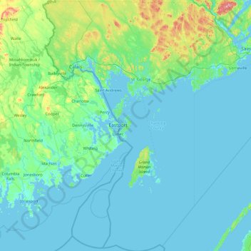
Name: Charlotte County topographic map, elevation, terrain.
Location: Charlotte County, New Brunswick, Canada (44.55612 -67.50372 45.51028 -66.45784)
Average elevation: 51 m
Minimum elevation: -2 m
Maximum elevation: 432 m
Other topographic maps
Click on a map to view its topography, its elevation and its terrain.
Clarendon Parish
Clarendon Parish, Charlotte County, New Brunswick, Canada
Average elevation: 160 m
Lower Lincoln
Canada > New Brunswick > Lower Lincoln
Lower Lincoln, Lincoln Parish, Sunbury County, New Brunswick, E2V 1G7, Canada
Average elevation: 8 m
Fundy National Park of Canada
Fundy National Park of Canada, 114, Albert County, New Brunswick, E4H 1N5, Canada
Average elevation: 230 m
The Wolves
The Wolves, Charlotte County, New Brunswick, Canada
Average elevation: 21 m