
Bouhanifia topographic map
Interactive map
Click on the map to display elevation.
About this map
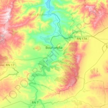
Name: Bouhanifia topographic map, elevation, terrain.
Location: Bouhanifia, Daïra Bouhanifia, Mascara, Algérie (35.23002 -0.24199 35.37618 0.00206)
Average elevation: 443 m
Minimum elevation: 166 m
Maximum elevation: 826 m
Other topographic maps
Click on a map to view its topography, its elevation and its terrain.
Hacine
Algérie > Mascara > Daïra Bouhanifia
Hacine, Daïra Bouhanifia, Mascara, Algérie
Average elevation: 345 m