
Federal District topographic map
Interactive map
Click on the map to display elevation.
About this map
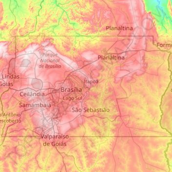
Name: Federal District topographic map, elevation, terrain.
Location: Federal District, Central-West Region, Brazil (-16.05056 -48.28579 -15.50018 -47.30839)
Average elevation: 983 m
Minimum elevation: 584 m
Maximum elevation: 1,349 m
Other topographic maps
Click on a map to view its topography, its elevation and its terrain.
Paranoá
Brazil > Federal District > Paranoá
Paranoá, Região Integrada de Desenvolvimento do Distrito Federal e Entorno, Federal District, Central-West Region, Brazil
Average elevation: 1,025 m