
Make a donation
Tingalpa Creek topographic map
Click on the map to display elevation.
Make a donation
About this map
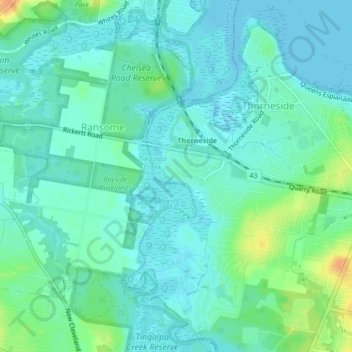
Name: Tingalpa Creek topographic map, elevation, terrain.
Location: Tingalpa Creek, Brisbane, Queensland, 4158, Australia (-27.50973 153.18412 -27.47216 153.19754)
Average elevation: 9 m
Minimum elevation: -1 m
Maximum elevation: 34 m
Make a donation
Other topographic maps
Click on a map to view its topography, its elevation and its terrain.
Lamb Island
Australia > Queensland > Brisbane
The island is in the southern part of Moreton Bay between the Queensland mainland and North Stradbroke Island. It is within the Moreton Bay Marine Park. The elevation ranges from 0 to 26 metres (0 to 85 ft) above sea level. The land use on the island is predominantly residential.
Average elevation: 4 m
Make a donation
Bribie Island
Australia > Queensland > Brisbane
Bribie Island, located in Queensland, Australia, is a low-lying, elongated landmass stretching approximately 34 kilometers (21 miles) in length and up to 8 kilometers (5 miles) at its widest point. Composed predominantly of coastal sand plains, the island features two large, low-lying dunes extending…
Average elevation: 6 m
Make a donation