
Barkly East topographic map
Interactive map
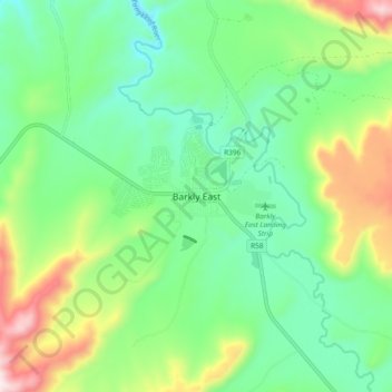
Click on the map to display elevation.
About this map
Name: Barkly East topographic map, elevation, terrain.
Average elevation: 1,838 m
Minimum elevation: 1,658 m
Maximum elevation: 2,234 m
Barkly East is a town in Eastern Cape Province, South Africa, seat of the Joe Gqabi District Municipality, and 117 km by road E.S.E. of Aliwal North, lying in the mountainous area just south of Lesotho. The town lies at the southern tip of the Drakensberg on the Langkloofspruit, a tributary of the Kraai River which, in turn is a tributary of the Orange River at an elevation of 1 790 meter (5 873 foot) above sealevel. Barkly East is characterized by rugged mountains and green valleys. Snow falls in winter, and the hamlet of Rhodes is 60 km or an hour's drive from Barkly East on the R396. Both are within the boundaries of the Senqu Local Municipality. It has been one of the few areas in South Africa where winter sports are pursued, and in summer fly fishing for Rainbow trout and indigenous Smallmouth yellowfish, trail running, mountain biking, ancient rock-art, tennis and the magnificent scenery draw tourists to the district. A recent development is the mountainous terrain attracting off-road bikers who revel in traversing the numerous passes in the area. Even more recent is the opening of the winter fly fishing season on Wild Trout Association waters around Barkly East, Lady Grey, Rhodes and Wartrail.
Other topographic maps
Click on a map to view its topography, its elevation and its terrain.
Makalakaleng
South Africa > Eastern Cape > Joe Gqabi District Municipality > Senqu Local Municipality
Makalakaleng, Senqu Local Municipality, Joe Gqabi District Municipality, Eastern Cape, South Africa
Average elevation: 1,680 m