
Gran Canaria topographic map
Interactive map
Click on the map to display elevation.
Gran Canaria
Gran Canaria is located in the Atlantic Ocean in a region known as Macaronesia about 150 kilometres (93 mi) off the northwestern coast of Africa and about 1,350 km (840 mi) from Europe. With an area of 1,560 km2 (600 sq mi) and an altitude of 1,956 m (6,417 ft) at Morro de la Agujereada, Gran Canaria is the third largest island of the archipelago in both area and altitude. Gran Canaria is also the third most populated island in Spain.
About this map
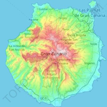
Name: Gran Canaria topographic map, elevation, terrain.
Location: Gran Canaria, Canary Islands, Spain (27.73458 -15.83465 28.18143 -15.35828)
Average elevation: 335 m
Minimum elevation: -1 m
Maximum elevation: 1,933 m
Other topographic maps
Click on a map to view its topography, its elevation and its terrain.
Pamplona
Spain > Navarre > Iruñerria / Comarca de Pamplona
The climate of Pamplona is classified as an oceanic climate (Köppen climate classification: Cfb) with influences of a Mediterranean climate (Csb). Due to global warming and stronger summer heat waves in the 21st century, it is also on the boundary with a humid subtropical climate (Cfa). Precipitation patterns…
Average elevation: 611 m
Alhambra
Spain > Andalusia > Comarca de la Vega de Granada > Granada
During the reign of the Nasrid Dynasty, the Alhambra was transformed into a palatine city, complete with an irrigation system composed of aqueducts and water channels that provided water for the complex and for other nearby countryside palaces such as the Generalife. Previously, the old fortresses on the hill…
Average elevation: 759 m