
Make a donation
Tucson topographic map
Click on the map to display elevation.
Make a donation
Tucson
Tucson is situated on an alluvial plain in the Sonoran Desert, at an elevation of approximately 2,400 feet (730 meters) above sea level. The city is enveloped by five mountain ranges, which contribute significantly to its varied topography. To the north lie the Santa Catalina and Tortolita Mountains, while the Santa Rita Mountains are located to the south. The Rincon Mountains are to the east, and the Tucson Mountains border the west. Among these, Mount Lemmon rises to 9,157 feet (2,791 meters) and is notable for being the southernmost ski destination in the continental U.S. Meanwhile, Mount Wrightson, the highest peak in the area, reaches 9,453 feet (2,881 meters). This mountainous backdrop, combined with the valley floor, creates a diverse landscape that is both striking and integral to the region's ecology and recreational opportunities.
Make a donation
About this map
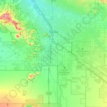
Name: Tucson topographic map, elevation, terrain.
Location: Tucson, Pima County, Arizona, United States (31.99041 -111.05823 32.32091 -110.70821)
Average elevation: 822 m
Minimum elevation: 651 m
Maximum elevation: 1,416 m
Make a donation
Other topographic maps
Click on a map to view its topography, its elevation and its terrain.
Make a donation
Make a donation
Make a donation
Tucson
United States > Arizona > Pima County > Tucson
The city's elevation is 2,643 ft (806 m) above sea level (as measured at the Tucson International Airport). Tucson is on an alluvial plain in the Sonoran Desert, surrounded by five minor ranges of mountains: the Santa Catalina Mountains and the Tortolita Mountains to the north, the Santa Rita Mountains to the…
Average elevation: 836 m
Make a donation
Make a donation
Make a donation