
Finnmark topographic map
Interactive map
Click on the map to display elevation.
About this map
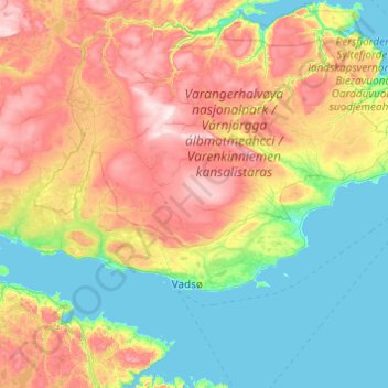
Name: Finnmark topographic map, elevation, terrain.
Location: Vesisaari, Finnmark, Norway (69.97504 28.98101 70.47779 30.93262)
Average elevation: 185 m
Minimum elevation: -1 m
Maximum elevation: 629 m
Other topographic maps
Click on a map to view its topography, its elevation and its terrain.
Vetle Skagastølstind
Vetle Skagastølstind, Luster, Sogn og Fjordane, Norway
Average elevation: 1,783 m
Jesus Lever-steinen
Jesus Lever-steinen, Løvstien, Solheims Boretslag, Solheim, Årstad, Gyldenpris, Bergen, Hordaland, 5057, Norway
Average elevation: 100 m