
Tsing Yi Promenade topographic map
Interactive map
Click on the map to display elevation.
About this map
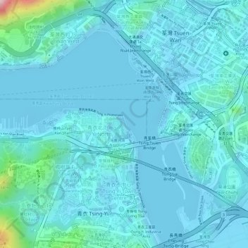
Name: Tsing Yi Promenade topographic map, elevation, terrain.
Average elevation: 27 m
Minimum elevation: -15 m
Maximum elevation: 250 m
Other topographic maps
Click on a map to view its topography, its elevation and its terrain.
Tsing Yi Park
PRC > Tsing Yi Fishermen's Village
Tsing Yi Park, Ha Kwai Chung, Tsing Yi Fishermen's Village, Kwai Tsing District, Hong Kong, PRC
Average elevation: 33 m
Tsing Chau
PRC > Tsing Yi Fishermen's Village
Tsing Chau, Tsing Yi Fishermen's Village, Kwai Tsing District, Hong Kong, 852, PRC
Average elevation: 23 m