
Nottingham Island topographic map
Interactive map
Click on the map to display elevation.
About this map
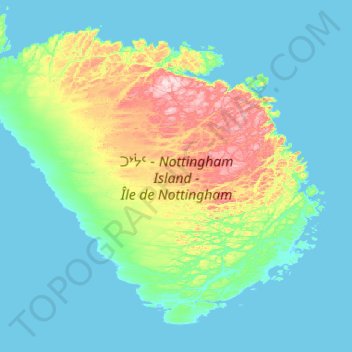
Name: Nottingham Island topographic map, elevation, terrain.
Location: Nottingham Island, Nunavut, Canada (63.08868 -78.53536 63.48717 -77.48911)
Average elevation: 61 m
Minimum elevation: -1 m
Maximum elevation: 408 m
Other topographic maps
Click on a map to view its topography, its elevation and its terrain.
Victoria and Albert Mountains
Victoria and Albert Mountains, Nunavut, Canada
Average elevation: 743 m
Sermilik Glacier
Sermilik Glacier, Sirmilik National Park, Nunavut, Canada
Average elevation: 1,188 m
Cornwallis Island
Cornwallis Island, Qikiqtani Region, Nunavut, X0A 0V0, Canada
Average elevation: 73 m
Prince of Wales Island
Prince of Wales Island, Nunavut, Canada
Average elevation: 31 m
Sirmilik National Park
Sirmilik National Park, Nunavut, Canada
Average elevation: 338 m