
Penida Island topographic map
Interactive map
Click on the map to display elevation.
About this map
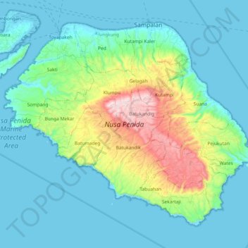
Name: Penida Island topographic map, elevation, terrain.
Average elevation: 104 m
Minimum elevation: -4 m
Maximum elevation: 517 m
Nusa Penida (Balinese: ᬦᬸᬲᬧᭂᬦᬶᬤ), romanized: nusapĕnida, lit. 'Penida Island') is an island located near the southeastern Indonesian island of Bali and a district of Klungkung Regency that includes the neighbouring small island of Nusa Lembongan and twelve even smaller islands. The Badung Strait separates the island and Bali. The interior of Nusa Penida is hilly with a maximum altitude of 524 metres. It is drier than the nearby island of Bali. It is one of the major tourist attractions among the three Nusa islands.
Other topographic maps
Click on a map to view its topography, its elevation and its terrain.
Bireuen
Indonesia > Bali > Klungkung Regency > Batukandik
Bireuen, Batukandik, Nusa Penida Subdistrict, Klungkung Regency, Bali, Lesser Sunda Islands, Indonesia
Average elevation: 82 m