
Sham Chun River topographic map
Interactive map
Click on the map to display elevation.
About this map
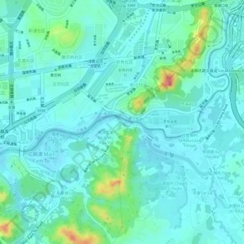
Name: Sham Chun River topographic map, elevation, terrain.
Average elevation: 18 m
Minimum elevation: 0 m
Maximum elevation: 84 m
Other topographic maps
Click on a map to view its topography, its elevation and its terrain.
Xiasha
PRC > Guangdong > Shenzhen City > Xiasha
Xiasha, Futian District, Shenzhen City, Guangdong, 518000, PRC
Average elevation: 18 m
Bao'an District
PRC > Guangdong > Shenzhen City
Bao'an District, Shenzhen City, Guangdong, 518100, PRC
Average elevation: 39 m
Futian District
PRC > Guangdong > Shenzhen City
Futian District, Shenzhen City, Guangdong, 518000, PRC
Average elevation: 49 m