
Sai Kung West Country Park topographic map
Interactive map
Click on the map to display elevation.
About this map
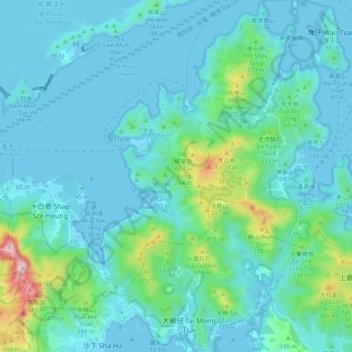
Name: Sai Kung West Country Park topographic map, elevation, terrain.
Average elevation: 95 m
Minimum elevation: -2 m
Maximum elevation: 658 m
Other topographic maps
Click on a map to view its topography, its elevation and its terrain.
Three Fathoms Cove
Three Fathoms Cove, Cheung Sheung Country Trail, Shap Sze Heung, Yung Shu O, Tai Po District, Hong Kong, DD165 1471, PRC
Average elevation: 70 m