
Bihar topographic map
Interactive map
Click on the map to display elevation.
About this map
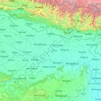
Name: Bihar topographic map, elevation, terrain.
Location: Bihar, India (24.28718 83.31585 27.52164 88.29200)
Average elevation: 606 m
Minimum elevation: 12 m
Maximum elevation: 8,419 m
Other topographic maps
Click on a map to view its topography, its elevation and its terrain.
Kuraitha Railway Station
Kuraitha Railway Station, Mansahi, Katihar, Bihar, 854103, India
Average elevation: 28 m