
Smithtown topographic map
Interactive map
Click on the map to display elevation.
About this map
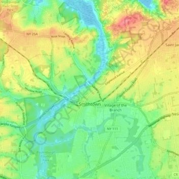
Name: Smithtown topographic map, elevation, terrain.
Location: Smithtown, Suffolk County, New York, 11787, United States (40.82676 -73.24826 40.89616 -73.16868)
Average elevation: 29 m
Minimum elevation: 0 m
Maximum elevation: 69 m
Other topographic maps
Click on a map to view its topography, its elevation and its terrain.
Smithtown Pines
United States > New York > Suffolk County > Smithtown
Smithtown Pines, Smithtown, Town of Smithtown, Suffolk County, New York, 11725, United States
Average elevation: 29 m
Caleb Smith State Park
United States > New York > Suffolk County > Smithtown > Smithtown Pines
Caleb Smith State Park, Smithtown Pines, Smithtown, Town of Smithtown, Suffolk County, New York, United States
Average elevation: 21 m