
Augsburg topographic map
Interactive map
Click on the map to display elevation.
About this map
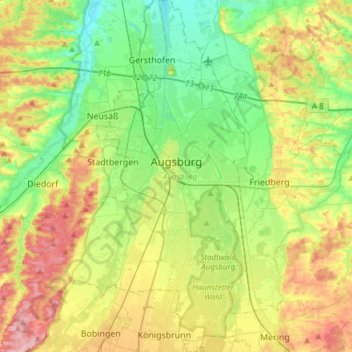
Name: Augsburg topographic map, elevation, terrain.
Location: Augsburg, Swabia, Bavaria, Germany (48.25814 10.76336 48.45865 10.95933)
Average elevation: 499 m
Minimum elevation: 445 m
Maximum elevation: 586 m
Other topographic maps
Click on a map to view its topography, its elevation and its terrain.
Funtensee
Germany > Bavaria > Landkreis Berchtesgadener Land > Schönau am Königssee
The lake lies at an elevation of 1601 m and has a surface area is 3.5 ha. Its outflow toward the Schrainbach is subterranean at a location called Teufelsmühle. On its shore is the Kärlinger Haus mountain hut which is open for the summer season; in addition, there is a winter room available. The valley is…
Average elevation: 1,813 m