
Millau topographic map
Interactive map
Click on the map to display elevation.
About this map
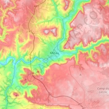
Name: Millau topographic map, elevation, terrain.
Location: Millau, Aveyron, Occitania, Metropolitan France, 12100, France (44.01667 2.99064 44.17985 3.24486)
Average elevation: 656 m
Minimum elevation: 331 m
Maximum elevation: 895 m
Other topographic maps
Click on a map to view its topography, its elevation and its terrain.
Peyrusse-le-Roc
Peyrusse-le-Roc, Villefranche-de-Rouergue, Aveyron, Occitania, Metropolitan France, 12220, France
Average elevation: 390 m