
Peru topographic map
Interactive map
Click on the map to display elevation.
About this map
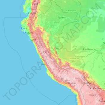
Name: Peru topographic map, elevation, terrain.
Location: Peru (-20.19845 -84.63565 -0.03928 -68.65199)
Average elevation: 645 m
Minimum elevation: -3 m
Maximum elevation: 6,020 m
The combination of tropical latitude, mountain ranges, topography variations, and two ocean currents (Humboldt and El Niño) gives Peru a large diversity of climates. The coastal region has moderate temperatures, low precipitation, and high humidity, except for its warmer, wetter northern reaches. In the mountain region, rain is frequent in summer, and temperature and humidity diminish with altitude up to the frozen peaks of the Andes. The Peruvian Amazon is characterized by heavy rainfall and high temperatures, except for its southernmost part, which has cold winters and seasonal rainfall.
Other topographic maps
Click on a map to view its topography, its elevation and its terrain.
Province of Abancay
Province of Abancay, Apurímac, 03041, Peru
Average elevation: 3,563 m
Ollantaytambo
Peru > Cusco > Ollantaytambo
Ollantaytambo, Province of Urubamba, Cusco, 08676, Peru
Average elevation: 3,929 m
IV
Peru > Lima > Villa El Salvador
IV, Villa El Salvador, Province of Lima, Lima, Peru
Average elevation: 91 m
Río Tumbes
Peru > Tumbes > Pampas de Hospital
Río Tumbes, Pampas de Hospital, Province of Tumbes, Tumbes, Peru
Average elevation: 422 m
Pueblo Libre
Peru > Lima > Pueblo Libre
Pueblo Libre, Province of Lima, Lima, Peru
Average elevation: 83 m
Distrito de Ayabaca
Peru > Piura > Distrito de Ayabaca
Distrito de Ayabaca, Province of Ayabaca, Piura, Peru
Average elevation: 1,946 m
Pueblo Libre
Peru > San Martín > Pueblo Libre
Pueblo Libre, Moyobamba, San Martín, Peru
Average elevation: 842 m
Los Baños del Inca
Peru > Cajamarca > Los Baños del Inca
Los Baños del Inca, Cajamarca, Peru
Average elevation: 3,282 m
Zona Arequeológica Monumental Pachacamac
Peru > Lima > Villa El Salvador
Zona Arequeológica Monumental Pachacamac, Avenida Lima, Villa El Salvador, Province of Lima, Lima, 15842, Peru
Average elevation: 47 m
San Martin de Porres
Peru > Tacna > San Martin de Porres
San Martin de Porres, Province of Tacna, Tacna, Peru
Average elevation: 51 m
Province of Pisco
Province of Pisco, Humay, Pisco, Ica, Peru
Average elevation: 587 m
Province of Jaén
Province of Jaén, Chontalí, Jaén, Cajamarca, Peru
Average elevation: 1,768 m
Fundo La Esperanza
Peru > Ica > Fundo La Esperanza
Fundo La Esperanza, Pisco, Ica, Peru
Average elevation: 245 m
Province of Huaylas
Peru > Ancash > Santa Cruz
Province of Huaylas, Santa Cruz, Huaylas, Ancash, Peru
Average elevation: 2,353 m
Montevideo
Peru > Apurímac > Montevideo
Montevideo, Chincheros, Apurímac, Peru
Average elevation: 3,249 m
Alpamayo
Peru > Ancash > Santa Cruz
Alpamayo, Santa Cruz, Huaylas, Ancash, Peru
Average elevation: 5,210 m
Province of Recuay
Province of Recuay, Cátac, Recuay, Ancash, Peru
Average elevation: 4,232 m
San Martín de Porres
Peru > Lima > San Martín de Porres
San Martín de Porres, Province of Lima, Lima, Peru
Average elevation: 55 m
Province of San Marcos
Peru > Cajamarca > José Sabogal
Province of San Marcos, José Sabogal, San Marcos, Cajamarca, Peru
Average elevation: 3,865 m
Zona Reservada Cordillera Huayhuash
Zona Reservada Cordillera Huayhuash, cutambo pass and siula grande view point, Cajatambo, Lima, Peru
Average elevation: 4,319 m
Cochabamba
Peru > Apurímac > Cochabamba
Cochabamba, Chincheros, Apurímac, Peru
Average elevation: 3,578 m