
Δήμος Καλαμαριάς topographic map
Interactive map
Click on the map to display elevation.
About this map
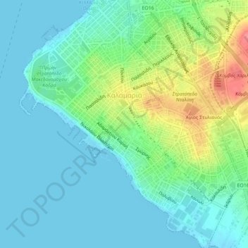
Name: Δήμος Καλαμαριάς topographic map, elevation, terrain.
Average elevation: 25 m
Minimum elevation: -2 m
Maximum elevation: 79 m
Other topographic maps
Click on a map to view its topography, its elevation and its terrain.
Χορτιάτης
Greece > Macedonia - Thrace > Χορτιάτης
Χορτιάτης, Δήμος Πυλαίας - Χορτιάτη, Thessaloniki Regional Unit, Central Macedonia Region, Macedonia - Thrace, 57010, Greece
Average elevation: 533 m
Mytikas
Greece > Macedonia - Thrace > Mytikas
Mytikas, Δήμος Κομοτηνής, Rodopi Regional Unit, East Macedonia and Thrace Region, Macedonia - Thrace, 69100, Greece
Average elevation: 507 m