
Grand County topographic map
Interactive map
Click on the map to display elevation.
About this map
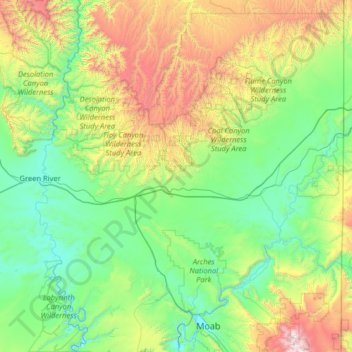
Name: Grand County topographic map, elevation, terrain.
Location: Grand County, Utah, USA (38.49951 -110.17937 39.49969 -109.05068)
Average elevation: 1,747 m
Minimum elevation: 1,201 m
Maximum elevation: 3,693 m
Other topographic maps
Click on a map to view its topography, its elevation and its terrain.
Timpanogos Glacier
USA > Utah > Aspen Grove
Timpanogos Glacier, Mount Timpanogos Trail #052, Aspen Grove, Utah County, Utah, USA
Average elevation: 3,148 m