
San Angel topographic map
Interactive map
Click on the map to display elevation.
About this map
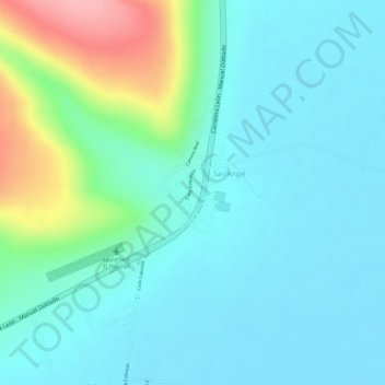
Name: San Angel topographic map, elevation, terrain.
Location: San Angel, Purísima del Rincón, Guanajuato, 36435, México (20.89400 -101.92484 20.90838 -101.91556)
Average elevation: 1,766 m
Minimum elevation: 1,733 m
Maximum elevation: 1,874 m
Other topographic maps
Click on a map to view its topography, its elevation and its terrain.
Purísima de Bustos
México > Guanajuato > Purísima del Rincón
Purísima de Bustos, Purísima del Rincón, Guanajuato, 36400, México
Average elevation: 1,826 m
Cañada de Negros
México > Guanajuato > Purísima del Rincón > Cañada de Negros
Cañada de Negros, Purísima del Rincón, Guanajuato, 36420, México
Average elevation: 1,800 m