
Jonesboro topographic map
Interactive map
Click on the map to display elevation.
About this map
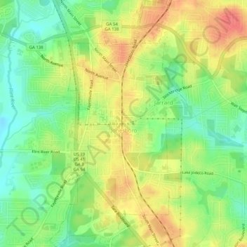
Name: Jonesboro topographic map, elevation, terrain.
Location: Jonesboro, Clayton County, Georgia, United States (33.50168 -84.36890 33.54346 -84.34073)
Average elevation: 269 m
Minimum elevation: 240 m
Maximum elevation: 298 m
Other topographic maps
Click on a map to view its topography, its elevation and its terrain.
Conley
United States > Georgia > Clayton County
Conley, Clayton County, Georgia, 30288, United States
Average elevation: 270 m
Bonanza
United States > Georgia > Clayton County
Bonanza, Clayton County, Georgia, 30250, United States
Average elevation: 272 m
Morrow
United States > Georgia > Clayton County
Morrow, Clayton County, Georgia, 30260, United States
Average elevation: 276 m
Mountain View
United States > Georgia > Clayton County > Coxs Crossing
Mountain View, Oak Forest, Coxs Crossing, Clayton County, Georgia, 30321, United States
Average elevation: 288 m
Irondale
United States > Georgia > Clayton County
Irondale, Clayton County, Georgia, 30238, United States
Average elevation: 269 m
Lake City
United States > Georgia > Clayton County
Lake City, Clayton County, Georgia, United States
Average elevation: 287 m
Forest Park
United States > Georgia > Clayton County
Forest Park, Clayton County, Georgia, 30297, United States
Average elevation: 283 m
Lovejoy
United States > Georgia > Clayton County
Lovejoy, Clayton County, Georgia, United States
Average elevation: 275 m
Forest Park
United States > Georgia > Clayton County > Forest Park
Forest Park, Clayton County, Georgia, 30297, United States
Average elevation: 283 m