
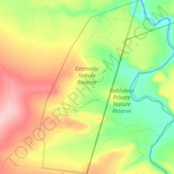
Ezemvelo Nature Reserve topographic map
Interactive map
Click on the map to display elevation.
About this map
Name: Ezemvelo Nature Reserve topographic map, elevation, terrain.
Average elevation: 1,360 m
Minimum elevation: 1,257 m
Maximum elevation: 1,476 m
Other topographic maps
Click on a map to view its topography, its elevation and its terrain.
Tshwane Ward 84
South Africa > Gauteng > City of Tshwane Metropolitan Municipality
Average elevation: 1,322 m
West Rand AH
South Africa > Gauteng > West Rand District Municipality > Westonaria Local Municipality
Average elevation: 1,600 m
Magaliesburg
South Africa > Gauteng > West Rand District Municipality > Mogale City Local Municipality
Average elevation: 1,504 m
Kruin Park
South Africa > Gauteng > City of Tshwane Metropolitan Municipality > Pretoria
Average elevation: 1,380 m
Ennerdale
South Africa > Gauteng > City of Johannesburg Metropolitan Municipality
Average elevation: 1,630 m
Northcliff Koppie
South Africa > Gauteng > City of Johannesburg Metropolitan Municipality > Johannesburg
Average elevation: 1,697 m
Nigel
South Africa > Gauteng > City of Ekurhuleni Metropolitan Municipality
Average elevation: 1,570 m
Carletonville
South Africa > Gauteng > West Rand District Municipality > Merafong City Local Municipality
Average elevation: 1,539 m
City of Johannesburg Metropolitan Municipality
South Africa > Gauteng > City of Johannesburg Metropolitan Municipality
Average elevation: 1,615 m
Rietvallei 241-IQ
South Africa > Gauteng > West Rand District Municipality > Mogale City Local Municipality
Average elevation: 1,684 m
Alberton
South Africa > Gauteng > City of Ekurhuleni Metropolitan Municipality
Average elevation: 1,628 m
Merafong City Local Municipality
South Africa > Gauteng > West Rand District Municipality
Average elevation: 1,525 m
Roodepoort
South Africa > Gauteng > City of Johannesburg Metropolitan Municipality > Roodepoort
Average elevation: 1,612 m
Bronkhorstspruit
South Africa > Gauteng > City of Tshwane Metropolitan Municipality
Average elevation: 1,411 m
Randburg
South Africa > Gauteng > City of Johannesburg Metropolitan Municipality
Average elevation: 1,567 m
Heidelberg
South Africa > Gauteng > Sedibeng District Municipality > Lesedi Local Municipality > Heidelberg
Average elevation: 1,581 m
Mogale City Local Municipality
South Africa > Gauteng > West Rand District Municipality
Average elevation: 1,512 m
Hekpoort
South Africa > Gauteng > Mogale City Local Municipality > Hekpoort
Average elevation: 1,278 m
Midrand
South Africa > Gauteng > City of Johannesburg Metropolitan Municipality
Average elevation: 1,542 m