
Adams Lake topographic map
Interactive map
Click on the map to display elevation.
About this map
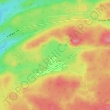
Name: Adams Lake topographic map, elevation, terrain.
Average elevation: 422 m
Minimum elevation: 368 m
Maximum elevation: 458 m
Other topographic maps
Click on a map to view its topography, its elevation and its terrain.
Paudash Lake
Canada > Ontario > Highlands East > Cardiff
Paudash Lake, Cardiff, Highlands East, Haliburton County, Central Ontario, Ontario, Canada
Average elevation: 368 m
Irondale River
Canada > Ontario > Highlands East
Irondale River, Highlands East, Haliburton County, Ontario, Canada
Average elevation: 381 m
Minnicock Lake
Canada > Ontario > Highlands East
Minnicock Lake, Minnicock Lake Road, Highlands East, Haliburton County, Central Ontario, Ontario, Canada
Average elevation: 386 m
Esson Lake
Canada > Ontario > Highlands East
Esson Lake, Sunset Cottage Road, Highlands East, Haliburton County, Central Ontario, Ontario, K0L 3C0, Canada
Average elevation: 421 m