
Bozrah topographic map
Interactive map
Click on the map to display elevation.
About this map
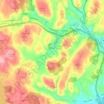
Name: Bozrah topographic map, elevation, terrain.
Location: Bozrah, New London County, Connecticut, United States (41.50401 -72.22819 41.59041 -72.13212)
Average elevation: 97 m
Minimum elevation: 18 m
Maximum elevation: 174 m
Other topographic maps
Click on a map to view its topography, its elevation and its terrain.
Ledyard
United States > Connecticut > New London County > Ledyard
Ledyard, New London County, Connecticut, United States
Average elevation: 53 m
Gales Ferry
United States > Connecticut > New London County > Ledyard > Gales Ferry
Gales Ferry, Ledyard, New London County, Connecticut, 06335, United States
Average elevation: 24 m
Hopeville Pond
United States > Connecticut > New London County > Griswold > Hopeville
Hopeville Pond, Hopeville, Griswold, New London County, Connecticut, United States
Average elevation: 59 m
Groton
United States > Connecticut > New London County > Groton
Groton, New London County, Connecticut, 06340, United States
Average elevation: 21 m
Groton Long Point
United States > Connecticut > New London County > Groton > Groton Long Point
Groton Long Point, Groton, New London County, Connecticut, United States
Average elevation: 2 m
Noank
United States > Connecticut > New London County > Groton > Noank
Noank, Groton, New London County, Connecticut, United States
Average elevation: 15 m
North Stonington
United States > Connecticut > New London County > North Stonington
North Stonington, New London County, Connecticut, United States
Average elevation: 78 m
Quaker Hill
United States > Connecticut > New London County > Waterford > Quaker Hill
Quaker Hill, Waterford, New London County, Connecticut, 06375, United States
Average elevation: 35 m
Pachaug
United States > Connecticut > New London County > Griswold > Pachaug
Pachaug, Griswold, New London County, Connecticut, 06351, United States
Average elevation: 70 m
Poquonock Bridge
United States > Connecticut > New London County > Groton > Poquonock Bridge
Poquonock Bridge, Groton, New London County, Connecticut, United States
Average elevation: 20 m
New London
United States > Connecticut > New London County > New London
New London, New London County, Connecticut, 06320, United States
Average elevation: 17 m
Griswold
United States > Connecticut > New London County
Griswold, New London County, Connecticut, United States
Average elevation: 70 m
Mystic
United States > Connecticut > New London County > Stonington > Mystic
Mystic, Stonington, New London County, Connecticut, 06355, United States
Average elevation: 14 m