
Ashmore and Cartier Islands topographic map
Interactive map
Click on the map to display elevation.
About this map
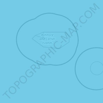
Name: Ashmore and Cartier Islands topographic map, elevation, terrain.
Location: Ashmore and Cartier Islands, Australia (-12.74819 122.72277 -11.97366 123.78634)
Average elevation: 0 m
Minimum elevation: 0 m
Maximum elevation: 0 m
Other topographic maps
Click on a map to view its topography, its elevation and its terrain.
Adelaide
Australia > South Australia > Adelaide
South Australia was officially established as a British Province in England in February 1836. The first Governor proclaimed the commencement of colonial government in South Australia on 28 December 1836, near The Old Gum Tree in what is now the suburb of Glenelg North. The event is commemorated in South…
Average elevation: 148 m
Perth
Australia > Western Australia > City of Perth
Perth, the capital of Western Australia, is situated on the Swan Coastal Plain, a flat expanse of sandy soil nestled between the Indian Ocean to the west and the Darling Scarp to the east. The Darling Scarp, also known as the Darling Range, is a low escarpment that extends north–south, marking a distinct…
Average elevation: 26 m
Dandenong Ranges
Australia > Victoria > Melbourne
The topography consists of a series of ridges dissected by deeply cut streams. Sheltered gullies in the south of the range are home to temperate rain forest, fern gullies and Mountain Ash forest Eucalyptus regnans, whereas the drier ridges and exposed northern slopes are covered by dry sclerophyll forest of…
Average elevation: 456 m
MacDonnell Ranges
The highest peaks are Mount Zeil with an elevation of 1,531 metres (5,023 ft) AHD, Mount Liebig at 1,524 metres (5,000 ft) AHD, Mount Edward at 1,423 metres (4,669 ft), Mount Giles at 1,389 metres (4,557 ft) and Mount Sonder at 1,380 metres (4,530 ft) AHD; the five highest mountains in the Northern Territory.…
Average elevation: 594 m
Cooper Creek
Australia > South Australia > Pastoral Unincorporated Area > Innamincka
Average elevation: 39 m