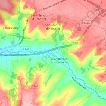
Saint-André-d'Hébertot topographic map
Interactive map
Click on the map to display elevation.
About this map
Name: Saint-André-d'Hébertot topographic map, elevation, terrain.
Average elevation: 92 m
Minimum elevation: 21 m
Maximum elevation: 155 m

Click on the map to display elevation.
Name: Saint-André-d'Hébertot topographic map, elevation, terrain.
Average elevation: 92 m
Minimum elevation: 21 m
Maximum elevation: 155 m