
Letchworth State Park topographic map
Interactive map
Click on the map to display elevation.
About this map
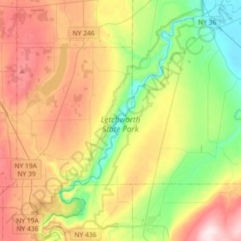
Name: Letchworth State Park topographic map, elevation, terrain.
Average elevation: 357 m
Minimum elevation: 168 m
Maximum elevation: 615 m
Other topographic maps
Click on a map to view its topography, its elevation and its terrain.
Walkers Corners
United States > New York > Livingston County
Walkers Corners, Town of York, Livingston County, New York, 14533, United States
Average elevation: 282 m
Village of Avon
United States > New York > Livingston County > Town of Avon
Village of Avon, Town of Avon, Livingston County, New York, United States
Average elevation: 192 m
Groveland Station
United States > New York > Livingston County
Groveland Station, Town of Groveland, Livingston County, New York, United States
Average elevation: 201 m
Town of Groveland
United States > New York > Livingston County
Town of Groveland, Livingston County, New York, United States
Average elevation: 278 m
Village of Lima
United States > New York > Livingston County
Village of Lima, Town of Lima, Livingston County, New York, United States
Average elevation: 253 m
Hemlock
United States > New York > Livingston County
Hemlock, Town of Livonia, Livingston County, New York, United States
Average elevation: 305 m
Town of Mount Morris
United States > New York > Livingston County
Town of Mount Morris, Livingston County, New York, 14510, United States
Average elevation: 267 m
Town of York
United States > New York > Livingston County
Town of York, Livingston County, New York, United States
Average elevation: 239 m
Hunt
United States > New York > Livingston County
Hunt, Town of Portage, Livingston County, New York, United States
Average elevation: 432 m
Village of Geneseo
United States > New York > Livingston County > Town of Geneseo
Village of Geneseo, Town of Geneseo, Livingston County, New York, United States
Average elevation: 218 m
Village of Dansville
United States > New York > Livingston County
Village of Dansville, Town of North Dansville, Livingston County, New York, 14437, United States
Average elevation: 290 m
Pine Tavern
United States > New York > Livingston County
Pine Tavern, Town of Leicester, Livingston County, New York, 14481, United States
Average elevation: 283 m
Sonyea
United States > New York > Livingston County
Sonyea, Town of Groveland, Livingston County, New York, 14556, United States
Average elevation: 198 m
Town of Portage
United States > New York > Livingston County
Town of Portage, Livingston County, New York, 14846, United States
Average elevation: 388 m
Dansville
United States > New York > Livingston County > Dansville
Dansville, Town of North Dansville, Livingston County, New York, 14437, United States
Average elevation: 277 m
Idaho
United States > New York > Livingston County > Town of Lima > Idaho
Idaho, Town of Lima, Livingston County, New York, 14585, United States
Average elevation: 262 m
Town of Geneseo
United States > New York > Livingston County
Town of Geneseo, Livingston County, New York, 14454, United States
Average elevation: 230 m
Conesus
United States > New York > Livingston County
Conesus, Livingston County, New York, 14435, United States
Average elevation: 388 m