
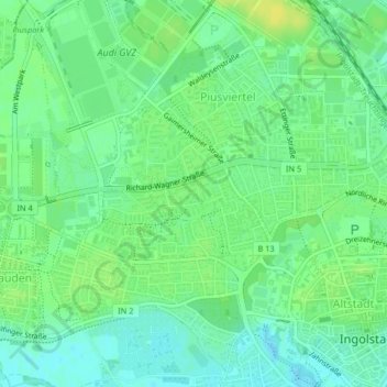
Richard-Strauss-Straße topographic map
Interactive map
Click on the map to display elevation.
About this map
Name: Richard-Strauss-Straße topographic map, elevation, terrain.
Average elevation: 377 m
Minimum elevation: 368 m
Maximum elevation: 386 m
Other topographic maps
Click on a map to view its topography, its elevation and its terrain.
85049
Deutschland > Bayern > Ingolstadt
85049, West, Ingolstadt, Bayern, Deutschland
Average elevation: 377 m
Dünzlau
Deutschland > Bayern > Ingolstadt > Dünzlauer Mühle
Dünzlau, Dünzlauer Mühle, West, Ingolstadt, Bayern, 85049, Deutschland
Average elevation: 378 m
Niederfeld
Deutschland > Bayern > Ingolstadt
Niederfeld, Südost, Ingolstadt, Bayern, Deutschland
Average elevation: 365 m
Unterbrunnenreuth
Deutschland > Bayern > Ingolstadt
Unterbrunnenreuth, Süd, Ingolstadt, Bayern, Deutschland
Average elevation: 369 m
Irgertsheim
Deutschland > Bayern > Ingolstadt
Irgertsheim, West, Ingolstadt, Bayern, Deutschland
Average elevation: 385 m
Zuchering
Deutschland > Bayern > Ingolstadt > Zuchering
Zuchering, Ingolstadt, Bayern, 85051, Deutschland
Average elevation: 370 m
Gerolfing Nord
Deutschland > Bayern > Ingolstadt > Gerolfing Nord
Gerolfing Nord, West, Ingolstadt, Bayern, 85049, Deutschland
Average elevation: 374 m