
Leak Island topographic map
Interactive map
Click on the map to display elevation.
About this map
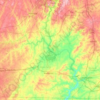
Name: Leak Island topographic map, elevation, terrain.
Average elevation: 130 m
Minimum elevation: 28 m
Maximum elevation: 267 m
Other topographic maps
Click on a map to view its topography, its elevation and its terrain.
Rockingham
United States > North Carolina > Richmond County
Rockingham, Richmond County, North Carolina, United States
Average elevation: 83 m
Maplewood
United States > North Carolina > Richmond County > Rockingham > Maplewood
Maplewood, Rockingham, Richmond County, North Carolina, 28379, United States
Average elevation: 83 m
Ellerbe
United States > North Carolina > Richmond County > Ellerbe
Ellerbe, Richmond County, North Carolina, United States
Average elevation: 145 m