
Les Grésillons topographic map
Interactive map
Click on the map to display elevation.
About this map
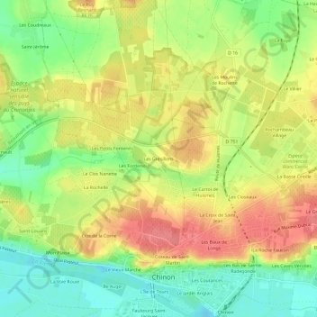
Name: Les Grésillons topographic map, elevation, terrain.
Average elevation: 64 m
Minimum elevation: 24 m
Maximum elevation: 103 m
Other topographic maps
Click on a map to view its topography, its elevation and its terrain.
La Ville
France > Centre-Val de Loire > Indre-et-Loire > Chinon > La Ville
La Ville, Chinon, Indre-et-Loire, Centre-Val de Loire, France métropolitaine, 37500, France
Average elevation: 52 m
Le Jardin Anglais
France > Centre-Val de Loire > Indre-et-Loire > Chinon
Le Jardin Anglais, Chinon, Indre-et-Loire, Centre-Val de Loire, France métropolitaine, 37500, France
Average elevation: 52 m
Saint-Jean
France > Centre-Val de Loire > Indre-et-Loire > Chinon
Saint-Jean, Chinon, Indre-et-Loire, Centre-Val de Loire, France métropolitaine, 37500, France
Average elevation: 59 m
Mon Plaisir
France > Centre-Val de Loire > Indre-et-Loire > Chinon
Mon Plaisir, Chinon, Indre-et-Loire, Centre-Val de Loire, France métropolitaine, 37500, France
Average elevation: 50 m
L'Île de Tours
France > Centre-Val de Loire > Indre-et-Loire > Chinon
L'Île de Tours, Chinon, Indre-et-Loire, Centre-Val de Loire, France métropolitaine, 37500, France
Average elevation: 51 m
Les Courances
France > Centre-Val de Loire > Indre-et-Loire > Chinon
Les Courances, Chinon, Indre-et-Loire, Centre-Val de Loire, France métropolitaine, 37500, France
Average elevation: 54 m
La Croix de Saint-Jean
France > Centre-Val de Loire > Indre-et-Loire > Chinon
La Croix de Saint-Jean, Chinon, Indre-et-Loire, Centre-Val de Loire, France métropolitaine, 37500, France
Average elevation: 62 m
La Ville
France > Centre-Val de Loire > Indre-et-Loire > Chinon
La Ville, Chinon, Indre-et-Loire, Centre-Val de Loire, France métropolitaine, 37500, France
Average elevation: 53 m
Les Hucherolles
France > Centre-Val de Loire > Indre-et-Loire > Chinon > Les Hucherolles
Les Hucherolles, Chinon, Indre-et-Loire, Centre-Val de Loire, France métropolitaine, 37500, France
Average elevation: 57 m
Les Ganaudières
France > Centre-Val de Loire > Indre-et-Loire > Chinon > Les Ganaudières
Les Ganaudières, Chinon, Indre-et-Loire, Centre-Val de Loire, France métropolitaine, 37500, France
Average elevation: 61 m
Le Vieux Marché
France > Centre-Val de Loire > Indre-et-Loire > Chinon
Le Vieux Marché, Chinon, Indre-et-Loire, Centre-Val de Loire, France métropolitaine, 37500, France
Average elevation: 51 m
Le Bois de la Grille
France > Centre-Val de Loire > Indre-et-Loire > Chinon > Le Villier
Le Bois de la Grille, Le Villier, Chinon, Indre-et-Loire, Centre-Val de Loire, France métropolitaine, 37500, France
Average elevation: 75 m
La Rochelle
France > Centre-Val de Loire > Indre-et-Loire > Chinon
La Rochelle, Chinon, Indre-et-Loire, Centre-Val de Loire, France métropolitaine, 37500, France
Average elevation: 58 m
Coteau de Saint-Martin
France > Centre-Val de Loire > Indre-et-Loire > Chinon
Coteau de Saint-Martin, Chinon, Indre-et-Loire, Centre-Val de Loire, France métropolitaine, 37500, France
Average elevation: 55 m
La Croix
France > Centre-Val de Loire > Indre-et-Loire > Chinon > La Croix
La Croix, Chinon, Indre-et-Loire, Centre-Val de Loire, France métropolitaine, 37500, France
Average elevation: 51 m
Faubourg Saint-Jacques
France > Centre-Val de Loire > Indre-et-Loire > Chinon
Faubourg Saint-Jacques, Chinon, Indre-et-Loire, Centre-Val de Loire, France métropolitaine, 37500, France
Average elevation: 50 m