
St Kilda West topographic map
Interactive map
Click on the map to display elevation.
About this map
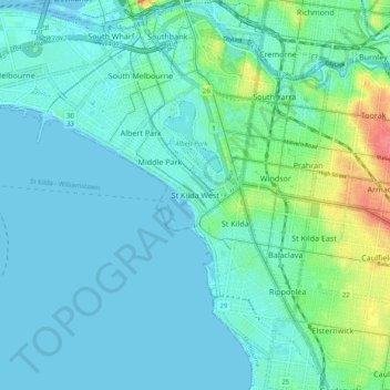
Name: St Kilda West topographic map, elevation, terrain.
Average elevation: 12 m
Minimum elevation: -6 m
Maximum elevation: 64 m
Other topographic maps
Click on a map to view its topography, its elevation and its terrain.
Albert Park District
Australia > Victoria > Melbourne > St Kilda West
Albert Park District, St Kilda West, Melbourne, City of Port Phillip, Victoria, 3182, Australia
Average elevation: 10 m