
Sana'a topographic map
Interactive map
Click on the map to display elevation.
About this map
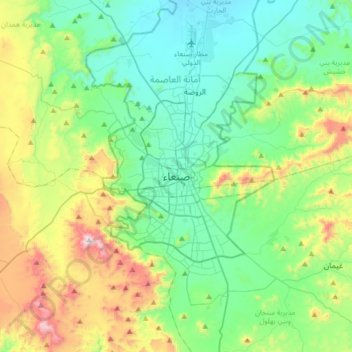
Name: Sana'a topographic map, elevation, terrain.
Location: Sana'a, At Tahrir District, Amanat Al Asimah, Yemen (15.19386 44.04588 15.51386 44.36588)
Average elevation: 2,443 m
Minimum elevation: 2,172 m
Maximum elevation: 3,193 m
At an elevation of 2,300 metres (7,500 ft), Sanaa is one of the highest capital cities in the world and is next to the Sarawat Mountains of Jabal An-Nabi Shu'ayb and Jabal Tiyal, considered to be the highest mountains in the country and amongst the highest in the region. Sanaa has a population of approximately 3,937,500 (2012), making it Yemen's largest city. As of 2020, the greater Sanaa urban area makes up about 10% of Yemen's total population.