
Madison topographic map
Interactive map
Click on the map to display elevation.
About this map
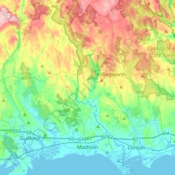
Name: Madison topographic map, elevation, terrain.
Average elevation: 69 m
Minimum elevation: -2 m
Maximum elevation: 219 m
Other topographic maps
Click on a map to view its topography, its elevation and its terrain.
Lake Whitney
United States > Connecticut > South Central COG > Hamden
Lake Whitney, Hamden, South Central COG, Connecticut, United States
Average elevation: 25 m
Branford Hills
United States > Connecticut > South Central COG > Branford
Branford Hills, Branford, South Central COG, Connecticut, 06405, United States
Average elevation: 12 m
North Guilford
United States > Connecticut > South Central COG > Guilford
North Guilford, Guilford, South Central COG, Connecticut, United States
Average elevation: 79 m
Whitney Peak
United States > Connecticut > South Central COG > Hamden
Whitney Peak, Hamden, South Central COG, Connecticut, 06517, United States
Average elevation: 19 m