
Gehaus topographic map
Interactive map
Click on the map to display elevation.
About this map
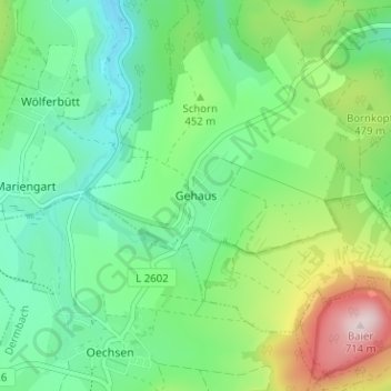
Name: Gehaus topographic map, elevation, terrain.
Location: Gehaus, Dermbach, Wartburgkreis, Thüringen, Deutschland (50.73955 10.05757 50.77955 10.09757)
Average elevation: 437 m
Minimum elevation: 320 m
Maximum elevation: 707 m
Gehaus ist ein Ortsteil von Dermbach im Wartburgkreis. Die in der Thüringer Rhön befindliche Ortschaft hat mit dem Ortsteil Hohenwart etwa 600 Einwohner und liegt etwa fünf Kilometer westlich von Stadtlengsfeld am Nordwesthang des Baier. Die geographische Höhe des Ortes beträgt 399 m ü. NN.
Other topographic maps
Click on a map to view its topography, its elevation and its terrain.
Auf der
Deutschland > Thüringen > Wartburgkreis > Dermbach > Stadtlengsfeld
Auf der, Stadtlengsfeld, Dermbach, Wartburgkreis, Thüringen, 36466, Deutschland
Average elevation: 332 m
Stadtlengsfeld
Deutschland > Thüringen > Wartburgkreis > Dermbach
Stadtlengsfeld, Dermbach, Wartburgkreis, Thüringen, Deutschland
Average elevation: 385 m