
Chester Township topographic map
Interactive map
Click on the map to display elevation.
About this map
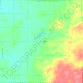
Name: Chester Township topographic map, elevation, terrain.
Average elevation: 233 m
Minimum elevation: 202 m
Maximum elevation: 290 m
Other topographic maps
Click on a map to view its topography, its elevation and its terrain.
Georgetown Charter Township
United States > Michigan > Ottawa County
Georgetown Charter Township, Ottawa County, Michigan, 49428, United States
Average elevation: 199 m
Port Sheldon
United States > Michigan > Ottawa County
Port Sheldon, Port Sheldon Township, Ottawa County, Michigan, United States
Average elevation: 185 m
Polkton Township
United States > Michigan > Ottawa County
Polkton Township, Ottawa County, Michigan, United States
Average elevation: 195 m
Coopersville
United States > Michigan > Ottawa County
Coopersville, Ottawa County, Michigan, 49404, United States
Average elevation: 200 m
Holland
United States > Michigan > Ottawa County > Holland
Holland, Ottawa County, Michigan, 49423, United States
Average elevation: 199 m
Allendale
United States > Michigan > Ottawa County > Allendale
Allendale, Allendale Charter Township, Ottawa County, Michigan, 49401, United States
Average elevation: 195 m
Zeeland
United States > Michigan > Ottawa County
Zeeland, Ottawa County, Michigan, 49464, United States
Average elevation: 192 m