
Sawall topographic map
Interactive map
Click on the map to display elevation.
About this map
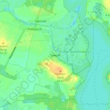
Name: Sawall topographic map, elevation, terrain.
Location: Sawall, Tauche, Oder-Spree, Brandenburg, Deutschland (52.05396 14.16191 52.09396 14.20191)
Average elevation: 45 m
Minimum elevation: 36 m
Maximum elevation: 63 m
Sawall liegt an einer Gemeindestraße nach Zaue. Die Bundesstraße 87 befindet sich etwa 1,5 Kilometer nordwestlich des Dorfes im Nachbarort Trebatsch. Sawall liegt unmittelbar an einem Altarm der Spree, westlich des Schwielochsees. Südlich von Sawall befindet sich der Swietenberg mit einer Höhe von 62 m ü. NHN.