
Thank you for supporting this site ❤️
Make a donation
Make a donation
La Chaussée de Damery topographic map
Click on the map to display elevation.
Thank you for supporting this site ❤️
Make a donation
Make a donation
About this map
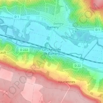
Name: La Chaussée de Damery topographic map, elevation, terrain.
Average elevation: 136 m
Minimum elevation: 61 m
Maximum elevation: 252 m
Thank you for supporting this site ❤️
Make a donation
Make a donation
Other topographic maps
Click on a map to view its topography, its elevation and its terrain.
Thank you for supporting this site ❤️
Make a donation
Make a donation
Thank you for supporting this site ❤️
Make a donation
Make a donation
Thank you for supporting this site ❤️
Make a donation
Make a donation
Thank you for supporting this site ❤️
Make a donation
Make a donation
Thank you for supporting this site ❤️
Make a donation
Make a donation
Argonne
The Forest of Argonne (French pronunciation: [aʁɡɔn] ) is a long strip of mountainous and wild woodland in northeastern France, approximately 200 km (120 mi) east of Paris. The forest measures roughly 65 km (40 mi) long and 15 km (9 mi) wide filled with many small hills and deep valleys formed by water…
Average elevation: 197 m
Thank you for supporting this site ❤️
Make a donation
Make a donation
Thank you for supporting this site ❤️
Make a donation
Make a donation
Thank you for supporting this site ❤️
Make a donation
Make a donation
Thank you for supporting this site ❤️
Make a donation
Make a donation
Thank you for supporting this site ❤️
Make a donation
Make a donation
Thank you for supporting this site ❤️
Make a donation
Make a donation
Thank you for supporting this site ❤️
Make a donation
Make a donation