
Village of Hoosick Falls topographic map
Interactive map
Click on the map to display elevation.
About this map
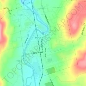
Name: Village of Hoosick Falls topographic map, elevation, terrain.
Average elevation: 166 m
Minimum elevation: 115 m
Maximum elevation: 249 m
Other topographic maps
Click on a map to view its topography, its elevation and its terrain.
Eagle Bridge
United States > New York > Rensselaer County > Town of Hoosick
Eagle Bridge, Town of Hoosick, Rensselaer County, New York, 12028, United States
Average elevation: 161 m
Walloomsac Dam
United States > New York > Rensselaer County > Town of Hoosick > Walloomsac
Walloomsac Dam, Walloomsac, Town of Hoosick, Rensselaer County, New York, 12133, United States
Average elevation: 191 m