
Kent topographic map
Interactive map
Click on the map to display elevation.
About this map
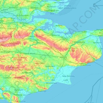
Name: Kent topographic map, elevation, terrain.
Location: Kent, South East, England, United Kingdom (50.91048 0.03352 51.48227 1.45177)
Average elevation: 37 m
Minimum elevation: -3 m
Maximum elevation: 263 m
Kent was also the location of the largest number of art schools in the country during the nineteenth century, estimated by the art historian David Haste, to approach two hundred. This is believed to be the result of Kent being a front line county during the Napoleonic Wars. At this time, before the invention of photography, draughtsmen were used to draw maps and topographical representations of the fields of battle, and after the wars ended many of these settled permanently in the county in which they had been based. Once the idea of art schools had been established, even in small towns in Kent, the tradition continued, although most of the schools were very small one man operations, each teaching a small number of daughters of the upper classes how to draw and make watercolour paintings. Nonetheless, some of these small art schools developed into much larger organisations, including Canterbury College of Art, founded by Thomas Sidney Cooper in 1868, which is today the University for the Creative Arts.
Other topographic maps
Click on a map to view its topography, its elevation and its terrain.
Ipswich
United Kingdom > England > Suffolk
Ipswich, Suffolk, England, United Kingdom
Average elevation: 29 m
Oswestry
United Kingdom > England > Shropshire
Oswestry, Shropshire, England, SY11 1PX, United Kingdom
Average elevation: 158 m
Evesham
United Kingdom > England > Worcestershire > Wychavon
Evesham, Wychavon, Worcestershire, England, United Kingdom
Average elevation: 38 m
Coleford
United Kingdom > England > Gloucestershire > Forest of Dean
Coleford, Forest of Dean, Gloucestershire, England, United Kingdom
Average elevation: 193 m
Milborne St Andrew
United Kingdom > England > Dorset
Milborne St Andrew, Dorset, England, DT11 0JF, United Kingdom
Average elevation: 96 m
Henley-on-Thames
United Kingdom > England > Oxfordshire > South Oxfordshire
Henley-on-Thames, South Oxfordshire, Oxfordshire, England, RG9 2AN, United Kingdom
Average elevation: 78 m
Bream
United Kingdom > England > Gloucestershire > Forest of Dean
Bream, Forest of Dean, Gloucestershire, England, GL15 6LE, United Kingdom
Average elevation: 122 m
Yorkley
United Kingdom > England > Gloucestershire > Forest of Dean
Yorkley, Forest of Dean, Gloucestershire, England, GL15 4TL, United Kingdom
Average elevation: 113 m
Newbiggin
United Kingdom > England > Westmorland and Furness
Newbiggin, Westmorland and Furness, England, United Kingdom
Average elevation: 146 m
Wycliffe
United Kingdom > England > County Durham
Wycliffe, Wycliffe with Thorpe, County Durham, North East, England, DL12 9TS, United Kingdom
Average elevation: 129 m
Lichfield
United Kingdom > England > Staffordshire > Lichfield
Lichfield, Staffordshire, England, United Kingdom
Average elevation: 91 m
Walshaw and Lancashire Moor
United Kingdom > England > Calderdale
Walshaw and Lancashire Moor, Wadsworth, Calderdale, West Yorkshire, England, BD22 9RQ, United Kingdom
Average elevation: 391 m
Branston
United Kingdom > England > Staffordshire > East Staffordshire
Branston, East Staffordshire, Staffordshire, England, DE14 3HX, United Kingdom
Average elevation: 55 m
Branston
United Kingdom > England > Lincolnshire > North Kesteven
Branston, North Kesteven, Lincolnshire, England, LN4 1NN, United Kingdom
Average elevation: 40 m
Disley
United Kingdom > England > Cheshire East
Disley, Cheshire East, England, United Kingdom
Average elevation: 229 m
Cleeve Hill
United Kingdom > England > Worcestershire > Wychavon
Cleeve Hill, Wychavon, Worcestershire, England, WR11 8QS, United Kingdom
Average elevation: 38 m
Hepscott
United Kingdom > England > Northumberland
Hepscott, Northumberland, North of Tyne, England, NE61 6LT, United Kingdom
Average elevation: 48 m
Rotherham
Rotherham, South Yorkshire, England, United Kingdom
Average elevation: 101 m
Keyworth
United Kingdom > England > Nottinghamshire > Rushcliffe
Keyworth, Rushcliffe, Nottinghamshire, England, United Kingdom
Average elevation: 68 m
Poynton
United Kingdom > England > Cheshire East
Poynton, Cheshire East, England, SK12 1GP, United Kingdom
Average elevation: 130 m
Stockport
Stockport, Greater Manchester, England, United Kingdom
Average elevation: 95 m
Whaley Bridge
United Kingdom > England > Derbyshire > High Peak
Whaley Bridge, High Peak, Derbyshire, England, United Kingdom
Average elevation: 266 m
Marple
Marple, Stockport, Greater Manchester, England, SK6 6DB, United Kingdom
Average elevation: 145 m
North Lincolnshire
North Lincolnshire, England, United Kingdom
Average elevation: 22 m
Cliddesden
United Kingdom > England > Hampshire > Basingstoke and Deane > Cliddesden
Cliddesden, Basingstoke and Deane, Hampshire, England, United Kingdom
Average elevation: 137 m
Lancaster
United Kingdom > England > Lancashire
Lancaster, Lancashire, England, United Kingdom
Average elevation: 84 m
Greenham
United Kingdom > England > West Berkshire
Greenham, West Berkshire, England, United Kingdom
Average elevation: 94 m
Stratford-upon-Avon
United Kingdom > England > Warwickshire > Stratford-on-Avon
Stratford-upon-Avon, Stratford-on-Avon, Warwickshire, England, United Kingdom
Average elevation: 61 m
Malvern
United Kingdom > England > Worcestershire > Malvern Hills
Malvern, Malvern Hills, Worcestershire, England, WR14 2HX, United Kingdom
Average elevation: 95 m
Berry Island
United Kingdom > England > Westmorland and Furness > Low Wood > High Brow Edge
Berry Island, High Brow Edge, Haverthwaite, Low Wood, Westmorland and Furness, England, United Kingdom
Average elevation: 68 m
Tyne and Wear
United Kingdom > England > County Durham
Tyne and Wear, County Durham, North East, England, United Kingdom
Average elevation: 82 m
Cobham
United Kingdom > England > Surrey > Elmbridge
Cobham, Elmbridge, Surrey, England, United Kingdom
Average elevation: 28 m
Woking
United Kingdom > England > Surrey
Woking, Surrey, England, United Kingdom
Average elevation: 38 m
West Horsley
United Kingdom > England > Surrey > Guildford
West Horsley, Guildford, Surrey, England, United Kingdom
Average elevation: 103 m
Egham
United Kingdom > England > Surrey > Borough of Runnymede
Egham, Borough of Runnymede, Surrey, England, United Kingdom
Average elevation: 25 m
Ascot
United Kingdom > England > Royal Borough of Windsor and Maidenhead
Ascot, Royal Borough of Windsor and Maidenhead, England, SL5 7FW, United Kingdom
Average elevation: 72 m
Sutton
United Kingdom > England > London
Sutton, London, Greater London, England, SM1 1DR, United Kingdom
Average elevation: 63 m
Royal Borough of Greenwich
United Kingdom > England > London
Royal Borough of Greenwich, London, Greater London, England, United Kingdom
Average elevation: 32 m
Christchurch
United Kingdom > England > Bournemouth, Christchurch and Poole > Hurn
Christchurch, Hurn, Bournemouth, Christchurch and Poole, England, United Kingdom
Average elevation: 18 m
Warrington
United Kingdom > England > Warrington
Warrington, England, WA1 1TS, United Kingdom
Average elevation: 20 m
Lowton St Mary's
United Kingdom > England > Wigan
Lowton St Mary's, Wigan, Greater Manchester, England, WA3 2NQ, United Kingdom
Average elevation: 32 m
Bracknell
United Kingdom > England > Bracknell Forest
Bracknell, Bracknell Forest, England, United Kingdom
Average elevation: 80 m
Crowthorne
United Kingdom > England > Bracknell Forest
Crowthorne, Bracknell Forest, England, United Kingdom
Average elevation: 82 m
Axminster
United Kingdom > England > Devon > East Devon
Axminster, East Devon, Devon, England, United Kingdom
Average elevation: 86 m
Hope Cove
United Kingdom > England > Torbay > Torquay
Hope Cove, Wellswood, Torquay, Torbay, England, TQ1 2PH, United Kingdom
Average elevation: 19 m
St Albans
United Kingdom > England > Hertfordshire
St Albans, Hertfordshire, England, United Kingdom
Average elevation: 103 m
Goosnargh
United Kingdom > England > Lancashire > Preston
Goosnargh, Preston, Lancashire, England, PR3 2FS, United Kingdom
Average elevation: 67 m
Whittingham
United Kingdom > England > Lancashire > Preston > Goosnargh
Whittingham, Goosnargh, Preston, Lancashire, England, United Kingdom
Average elevation: 78 m
Longridge
United Kingdom > England > Lancashire > Ribble Valley > Longridge
Longridge, Ribble Valley, Lancashire, England, United Kingdom
Average elevation: 89 m
Higher Walton
United Kingdom > England > Lancashire > South Ribble
Higher Walton, South Ribble, Lancashire, England, PR5 4DH, United Kingdom
Average elevation: 39 m