
Gainesville topographic map
Interactive map
Click on the map to display elevation.
About this map
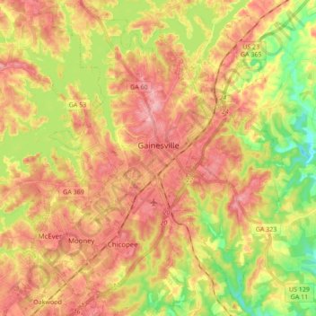
Name: Gainesville topographic map, elevation, terrain.
Location: Gainesville, Hall County, Georgia, 30501, United States (34.22117 -83.89959 34.36290 -83.75569)
Average elevation: 346 m
Minimum elevation: 266 m
Maximum elevation: 410 m
Other topographic maps
Click on a map to view its topography, its elevation and its terrain.
Clermont
United States > Georgia > Hall County
Clermont, Hall County, Georgia, United States
Average elevation: 425 m
Aqualand Park
United States > Georgia > Hall County
Aqualand Park, Hall County, Georgia, United States
Average elevation: 328 m
Oakwood
United States > Georgia > Hall County
Oakwood, Hall County, Georgia, United States
Average elevation: 358 m
Murrayville
United States > Georgia > Hall County
Murrayville, Hall County, Georgia, 30564, United States
Average elevation: 368 m
Candler
United States > Georgia > Hall County
Candler, Hall County, Georgia, 30507, United States
Average elevation: 313 m
Alandale
United States > Georgia > Hall County
Alandale, Hall County, Georgia, United States
Average elevation: 321 m
Bolman Estates
United States > Georgia > Hall County
Bolman Estates, Hall County, Georgia, 30507, United States
Average elevation: 314 m
Hidden Acres
United States > Georgia > Hall County
Hidden Acres, Hall County, Georgia, United States
Average elevation: 356 m
Lula
United States > Georgia > Hall County
Lula, Hall County, Georgia, 30554, United States
Average elevation: 369 m
Lake Lanier Islands Park
United States > Georgia > Hall County
Lake Lanier Islands Park, Hall County, Georgia, United States
Average elevation: 332 m
Flowery Branch
United States > Georgia > Hall County
Flowery Branch, Hall County, Georgia, 30542, United States
Average elevation: 343 m
Squirrel Creek
United States > Georgia > Hall County
Squirrel Creek, Hall County, Georgia, 30506, United States
Average elevation: 358 m
Green Crossing
United States > Georgia > Hall County > Buford
Green Crossing, Buford, Hall County, Georgia, United States
Average elevation: 354 m
Waverly Way
United States > Georgia > Hall County
Waverly Way, Hall County, Georgia, 30566, United States
Average elevation: 356 m
North Forest
United States > Georgia > Hall County > North Forest
North Forest, Hall County, Georgia, 50564, United States
Average elevation: 368 m
Brookton
United States > Georgia > Hall County > Brookton
Brookton, Hall County, Georgia, 30527, United States
Average elevation: 402 m