
Ealing topographic map
Interactive map
Click on the map to display elevation.
About this map
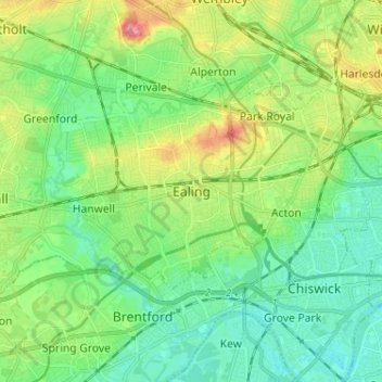
Name: Ealing topographic map, elevation, terrain.
Location: Ealing, Greater London, England, W5 5DG, United Kingdom (51.47266 -0.34520 51.55266 -0.26520)
Average elevation: 26 m
Minimum elevation: 0 m
Maximum elevation: 82 m
Other topographic maps
Click on a map to view its topography, its elevation and its terrain.
London
London's topography is characterized by a gently rolling terrain shaped by the River Thames and its tributaries. The city lies within the London Basin, a natural depression bordered by higher grounds such as the North Downs to the south and the Chiltern Hills to the northwest. The Thames flows west to east,…
Average elevation: 66 m
South East England
Near Weybridge are the UK headquarters of Sony with SSP Group (situated in Byfleet) and Procter & Gamble (next door to each other on The Heights Business Park near the former Brooklands racing circuit) with Kia Motors UK and Petroleum Geo-Services UK, and Gallaher Group (cigarettes) is to the north, next to…
Average elevation: 69 m
Farnham
United Kingdom > England > Surrey > Waverley
Farnham lies in the valley of the North Branch of the River Wey, which rises near Alton, merges with the South Branch at Tilford, and joins the River Thames at Weybridge. The mainly east-west alignment of the ridges and valleys has influenced the development of road and rail communications. The most prominent…
Average elevation: 100 m
Birmingham
Birmingham is a snowy city relative to other large UK conurbations, due to its inland location and comparatively high elevation. Between 1961 and 1990 Birmingham Airport averaged 13.0 days of snow lying annually, compared to 5.33 at London Heathrow. Snow showers often pass through the city via the Cheshire gap…
Average elevation: 138 m
Basingstoke
United Kingdom > England > Hampshire > Basingstoke and Deane
Situated in a valley through the Hampshire Downs at an average elevation of 88 metres (289 ft) Basingstoke is a major interchange between Reading, Newbury, Andover, Winchester, and Alton, and lies on the natural trade route between the southwest of England and London. The area had been something of an…
Average elevation: 110 m
Kent
Kent was also the location of the largest number of art schools in the country during the nineteenth century, estimated by the art historian David Haste, to approach two hundred. This is believed to be the result of Kent being a front line county during the Napoleonic Wars. At this time, before the invention…
Average elevation: 37 m
Lake District National Park
The Lake District is a roughly circular upland massif, deeply dissected by a broadly radial pattern of major valleys which are largely the result of repeated glaciations over the last 2 million years. The apparent radial pattern is not from a central dome, but from an axial watershed extending from St Bees…
Average elevation: 206 m
Kent
Kent was also the location of the largest number of art schools in the country during the nineteenth century, estimated by the art historian David Haste, to approach two hundred. This is believed to be the result of Kent being a front line county during the Napoleonic Wars. At this time, before the invention…
Average elevation: 37 m
Warwick
United Kingdom > England > Warwickshire
Warwick experiences the usual English maritime climate, marked by a narrow temperature range, mild winters and cool summers. The nearest official Met Office weather station is at Wellesbourne, about 6 miles (10 km) south of the town centre and at a similar elevation. The absolute maximum temperature (also the…
Average elevation: 87 m
Hertfordshire
Elevations are higher in the north and west, reaching more than 800 feet (240 m) in the Chilterns near Tring. The county centres on the headwaters and upper valleys of the rivers Lea and the Colne; both flow south, and each is accompanied by a canal. Hertfordshire's undeveloped land is mainly agricultural,…
Average elevation: 82 m
Cambridge
United Kingdom > England > Cambridge
The city, like most of the UK, has a maritime climate highly influenced by the Gulf Stream. Located in the driest region of Britain, Cambridge's rainfall averages around 570 mm (22.44 in) per year, around half the national average, with some years occasionally falling into the semi-arid (under 500 mm (19.69…
Average elevation: 18 m
Balderton
United Kingdom > England > Nottinghamshire > Newark and Sherwood > Balderton
Average elevation: 20 m
Ipswich
United Kingdom > England > Suffolk
Ipswich experiences an oceanic climate, like the rest of the British Isles, with a narrow range of temperature and rainfall spread evenly throughout the year. One of the two nearest for which data is available is East Bergholt, about 7 miles (11 km) south west of the town centre and at a similar elevation, and…
Average elevation: 29 m
St Albans
United Kingdom > England > Hertfordshire > St Albans
St Albans was an ancient borough created following the dissolution of the monastery in 1539. It consisted of the ancient parish of St Albans (also known as the Abbey parish) and parts of St Michael and St Peter. The municipal corporation was reformed by the Municipal Corporations Act 1835 and the boundary was…
Average elevation: 100 m
Former Seaton Ironworks Reservoir (disused)
United Kingdom > England > Cumberland > Workington > Stainburn
Average elevation: 32 m
Blea Tarn
United Kingdom > England > Cumberland > Boot > Beckfoot
Blea Tarn is a lake in Eskdale, Cumbria, in the English Lake District, located about half a mile north of Beckfoot. Located at an elevation of 217 m (712 ft), the lake has an area of 3.3 hectares (8.2 acres) and measures 277 m × 150 m (909 ft × 492 ft), with a maximum depth of 11 m (36 ft).
Average elevation: 144 m
Portsmouth
Portsmouth is 73.5 miles (118.3 km) by road from central London, 49.5 miles (79.7 km) west of Brighton, and 22.3 miles (35.9 km) east of Southampton. It is located primarily on Portsea Island and is the United Kingdom's only island city, although the city has expanded to the mainland. Gosport is a borough to…
Average elevation: 7 m
West Yorkshire
Wakefield's Parish Church was raised to cathedral status in 1888 and after the elevation of Wakefield to diocese, Wakefield Council immediately sought city status and this was granted in July 1888. However the industrial revolution, which changed West and South Yorkshire significantly, led to the growth of…
Average elevation: 172 m
South Downs National Park
United Kingdom > England > West Sussex
The South Downs National Park's chalk downland is a feature that sets it apart from other national parks in Britain. However, almost a quarter (23%) of the national park consists of a quite different and strongly contrasting physiographic region, the western Weald, whose densely wooded hills and vales are…
Average elevation: 54 m
Cambridgeshire
Cambridgeshire has a maritime temperate climate which is broadly similar to the rest of the United Kingdom, though it is drier than the UK average due to its low altitude and easterly location, the prevailing southwesterly winds having already deposited moisture on higher ground further west. Average winter…
Average elevation: 32 m
Surrey
United Kingdom > England > Surrey
The highest elevation in Surrey is Leith Hill near Dorking. It is 295 m (968 ft) above sea level and is the second highest point in southeastern England after Walbury Hill in West Berkshire which is 297 m (974 ft).
Average elevation: 69 m
Cornwall
The interior of the county consists of a roughly east–west spine of infertile and exposed upland, with a series of granite intrusions, such as Bodmin Moor, which contains the highest land within Cornwall. From east to west, and with approximately descending altitude, these are Bodmin Moor, Hensbarrow north…
Average elevation: 55 m
Bath
United Kingdom > England > Bath and North East Somerset
Bath is in the Avon Valley and is surrounded by limestone hills as it is near the southern edge of the Cotswolds, a designated Area of Outstanding Natural Beauty, and the limestone Mendip Hills rise around 7 miles (11 km) south of the city. The hills that surround and make up the city have a maximum altitude…
Average elevation: 100 m
Lincoln
United Kingdom > England > Lincolnshire
Lincoln lies 157 mi (253 km) north of London, at an altitude of 67 ft (20.4 m) by the River Witham up to 246 ft (75.0 m) on Castle Hill. It fills a gap in the Lincoln Cliff escarpment, which runs north and south through central Lincolnshire, with altitudes up to 200 feet (61 metres). The city lies on the River…
Average elevation: 29 m
Borough of Luton
The local climate around Luton is differentiated somewhat from much of South East England due to its position in the Chiltern Hills, meaning it tends to be 1–2 degrees Celsius cooler than the surrounding towns – often flights at Luton airport, lying 160 m (525 ft) above sea level, will be suspended when…
Average elevation: 146 m
Abbots Ripton
United Kingdom > England > Cambridgeshire > Huntingdonshire > Abbots Ripton
Average elevation: 38 m
Higham on the Hill
United Kingdom > England > Leicestershire > Hinckley and Bosworth
Average elevation: 94 m
Hemingford Grey
United Kingdom > England > Cambridgeshire > Huntingdonshire > Hemingford Grey
Average elevation: 11 m
Ashby de la Zouch Canal
United Kingdom > England > Leicestershire > North West Leicestershire > Moira
Average elevation: 100 m
Plymouth
The River Plym, which flows off Dartmoor to the north-east, forms a smaller estuary to the east of the city called Cattewater. Plymouth Sound is protected from the sea by the Plymouth Breakwater, in use since 1814. In the Sound is Drake's Island which is seen from Plymouth Hoe, a flat public area on top of…
Average elevation: 46 m
Yorkshire
In Yorkshire there is a very close relationship between the major topographical areas and the geological period in which they were formed. The Pennine chain of hills in the west is of Carboniferous origin. The central vale is Permo-Triassic. The North York Moors in the north-east of the county are Jurassic in…
Average elevation: 130 m
Haslemere
United Kingdom > England > Surrey > Waverley
Many of the roads in the area originated as medieval tracks and owing to the local topography, are narrow, twisting and steep. The principal route through Haslemere is the A286, which connects the town with Godalming and Grayswood (to the north) and with Midhurst (to the south). The A287 runs south from…
Average elevation: 150 m
Milford-on-Sea
United Kingdom > England > Hampshire > New Forest > Milford on Sea
Average elevation: 7 m